
1946 Stedman Pictorial Tourist Map of New Mexico

This item has been sold.
Recreational Map of New Mexico. The Land of Enchantment.
New Mexico's history, culture, and recreational opportunities.
Choose a Collection:
- Digital Map Information
- Suitable for large format printing
- Full resolution TIFF file
- ICC color profile embedded
- Delivered instantly via download link
This Item
Enquire
New Mexico's history, culture, and recreational opportunities.
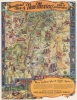
This is a 1946 first-edition Wilfred Stedman pictorial recreational map of New Mexico. The map celebrates New Mexico's culture and the many cultural and outdoor activities one can enjoy when visiting 'the Land of Enchantment.'A Closer Look
Vignettes highlight New Mexico's history and culture, including dancing Native Americans, a Spanish conquistador hiding behind a boulder, a covered wagon, and a group of outlaws on horseback in 'Billy the Kid Country.' Other vignettes promote modern life in New Mexico, such as ranching, while emphasizing recreational activities, like fishing, skiing, and swimming. Important sites around the state, including Carlsbad Caverns National Park, Chaco Canyon National Monument, Aztec Ruins National Monument, and White Sands Nationals Monument have their own vignettes. Banners label cities and towns, including Santa Fe, Albuquerque, and Taos.Publication History and Census
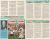
This map was drawn by Wilfred Stedman and published in 1946 by the New Mexico State Tourist Bureau. At least two editions of this map were published, with a later edition appearing in 1952 that bears different verso content. This map is well represented in institutional collections.Cartographer
Wilfred Stedman (1892 – 1950) was an English architect and illustrator active in Santa Fe, New Mexico in the first half of the 20th century. Born in Liverpool, Stedman later moved to New Mexico where he fell in love with the culture and natural beauty of the American southwest. Stedman's works include WPA projects and numerous collaborations with his wife, Myrtle Stedman, on such subjects as adobe houses, design, and southwestern architecture. Further Details...
Condition
Excellent. Light wear along original fold lines.
References
OCLC 1398422449.