
1905 Broadway Central Hotel Map or Plan of New York City

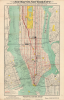
New Map of New York City. From the latest surveys showing all the ferries and steamship docks, elevated, subways electric and cross town car lines. / New Reference Map and Guide to New York City.
Constructing the Cosmopolis.
$275.00
Choose a Collection:
- Digital Map Information
- Suitable for large format printing
- Full resolution TIFF file
- ICC color profile embedded
- Delivered instantly via download link
This Item
Enquire
Constructing the Cosmopolis.
This is a c. 1905 folding promotional map of New York City issued by the Broadway Central Hotel, located at Broadway and Bleeker Street in Manhattan. It reflects the heady atmosphere of the early 20th century in New York City, facilitated by a range of new infrastructure projects, including the earliest subway lines, bridges across the East River, and railroad tunnels beneath the Hudson River.A Closer Look
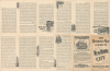
The map depicts Manhattan from Battery Park to 96th Street, as well as parts of New Jersey, Brooklyn, and Queens. Streets are labeled throughout. Parks are shaded yellow, streetcar lines and elevated railroads traced in red, railroads traced in black, and New York City's first subway line traced in a bold black line. Several locations are prominently marked, in addition to the Broadway Central Hotel, including Grand Central Station, Pennsylvania Station, and Wanamaker's department store. Additional hospitals, museums, educational institutions, piers (with their owners), ferry terminals and routes, train stations, and other features are recorded. Promotional text and illustrations of the Broadway Central Hotel and several city landmarks occupy the verso.Historical Context
The first decade of the 20th century was perhaps the most transformative era in New York City's history. Following the 1898 consolidation of the five boroughs into Greater New York, the city faced an urgent need to physically unite its sprawling territory. This period saw a stunning explosion of underground and overwater infrastructure that defined the modern metropolis. The most seismic shift occurred on October 27, 1904, with the opening of the city's first official rapid transit subway line. Operated by the Interborough Rapid Transit Company (IRT), the line ran from Downtown Brooklyn to Lower Manhattan (Wall Street, City Hall, etc.) and up Broadway to 96th Street. Unlike the noisy, soot-covered elevated trains of the late 19th century, the subway offered a clean, electrified, and incredibly fast alternative. This development immediately shifted the city's gravity, allowing workers to live in Upper Manhattan or Brooklyn while commuting to Lower Manhattan in a fraction of the time.Publication History and Census
This map was issued by the Broadway Central Hotel to its guests and, though undated, was likely printed around the year 1905. This date can be inferred from the inclusion of the IRT subway (and its discussion as being in operation on the verso). Other features on the map (the Manhattan Bridge, the Pennsylvania Railroad's North River Tunnels, the Hudson and Manhattan Railroad Tunnels) are also suggestive of a date in the mid- to late first decade of the 20th century. However, it is unclear whether they are under construction or completed, making an exact date difficult to pin down. The apparently incomplete nature and naming of the 'Belmont (Steinway) Tunnel,' when the IRT's founder August Belmont Jr. sought to complete the tunnel started by William Steinway in the late 19th century, would indicate a date before 1908. Similarly, the use of the name 'Blackwells Island Bridge,' which may also be incomplete, strongly suggests a date before 1909.This map was issued in at least two editions, distinguishable by the inclusion of 'Subways' in the title, as here. The map with this title (although with widely varying suggested dates) is cataloged among the holdings of the University of California, Santa Barbara; the University of Kentucky; the University of Minnesota, Twin Cities; the University of Michigan; and Yale University in the OCLC. The map is also sometimes cataloged under the title on the cover panel ('New Reference Map and Guide to New York City'), making it impossible to distinguish the two editions.
Condition
Very good. Slight verso repairs at a few fold intersections.
References
OCLC 35172995, 1176114242, 51958952.