
1970 Freya Tanz Promotional Pictorial Map of Oahu, Hawaii

Oahu. / Oahu Souvenir Map Hawaii.
Postwar Tourist Boom in Oahu.
Postwar Tourist Boom in Oahu.
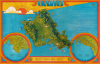
This is a c. 1970 pictorial promotional map of Oahu prepared by Freya Tanz. It was produced at a time when tourism from the U.S. mainland was surging, reorienting Oahu's economy. This shift brought clear economic benefits, but it also raised questions about the commodification of culture and sustainability that remain points of contention on Oahu today.A Closer Look
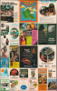
This is a cleverly designed promotional map, using numbers to indicate many businesses, which are then listed at the bottom, rather than leaving the map with the overly 'busy' look common to the genre. The main map presents Oahu in a bird's-eye view style to highlight the islands dramatic topography. Settlements and natural features are labeled throughout, while roads are traced and larger towns and cities, golf courses, military bases, pineapple plantations (namely those owned by Dole), and landmarks such as the Polynesian Cultural Center are illustrated and labeled. Additional illustrations refer to leisure activities like sailing and surfing. Other illustrations mark the locations and presence of companies highlighted in advertisements on the verso, including Dole, McDonald's, and Johnnie Walker. Insets at the bottom left and right present downtown Honolulu and Waikiki. Additional advertisements for services and tourist attractions appear on the verso.Historical Context
Interest in Hawaii, and Oahu more specifically, from the American mainland increased during and after World War II (1939 - 1945), driven by the large U.S. military presence there. This interest was further catalyzed by Hawaii's statehood in 1959 and the dawn of the commercial jet age. The introduction of non-stop jetliner routes in the late 1950s drastically reduced both travel times and airfares from the U.S. mainland, unleashing an unprecedented surge in visitors throughout the 1960s and 1970s. This influx fueled a high-rise construction boom that permanently reshaped Waikiki, turning Kalakaua Avenue into a dense corridor of landmark resorts and modern hotel towers. By the mid-1970s, tourism had surpassed sugar and pineapple as Hawaii's primary economic driver, shifting Oahu's labor market toward service industries while sparking public debates over urban density, environmental conservation, and the commercialization of Native Hawaiian culture that continue to the present.Publication History and Census
This map was prepared by Freya Tanz and published by Publications of Hawaii, most likely in the early 1970s. We note only two cataloged examples, at Brigham Young University and Harvard University.Cartographer
Freya Elfriede Tanz (March 15, 1942 - present) is an artist and animator. Tanz appears to have been born in Germany but come to the United States in her youth. She was active as a commercial artist in Hawaii in the early 1970s, including a travel poster designed for Hawaiian Airlines. In the 1980s, Tanz worked as an illustrator on several children's books, including Erica Jong's Megan's Book of Divorce and Megan's Two Houses. She is also credited as an animator on several films in the 1990s and early 2000s, including 'Beavis and Butt-Head Do America' and 'Doug's 1st Movie.' Further Details...
Condition
Good. Minor fill at the border, fold line, and both left and right sides. Wear on original fold lines, with slight loss at a few fold intersections.
References
OCLC 367573117.