
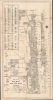
1951 Brockway Map of Palm Beach and West Palm Beach, Florida


This item has been sold.
Street Map of Palm Beach and West Palm Beach Florida.
Names both the homes of the ultra-elite and segregated 'colored' zones.
- Digital Map Information
- Suitable for large format printing
- Full resolution TIFF file
- ICC color profile embedded
- Delivered instantly via download link
Names both the homes of the ultra-elite and segregated 'colored' zones.
This is a c. 1951 George Samuel Brockway map of Palm Beach and West Palm Beach, Florida. It was issued during the post-WWII heyday of Palm Beach's lavish opulence as a resort for high society. The map names the owners of the great estates, and, as well, identifies segregated 'colored' areas.A Closer Look
This map covers the cities of Palm Beach and West Palm Beach, along with neighboring communities like Riviera Beach and Magnolia Park, focusing on streets, which are labeled and also listed in an index at left corresponding to a grid surrounding the map. Aside from streets, waterways, parks, cemeteries, golf courses, and public institutions like schools, hospitals, libraries, and government buildings. The owners of larger waterfront properties in Palm Beach are listed - including Joseph E. Davies, husband of Marjorie Merriweather Post (1887 - 1973), owner and builder of Mar-a-Lago. However, she herself is curiously not named. Notably, several locations (schools, parks, cemeteries) in the northern part of West Palm Beach are labeled as 'Colored,' reflecting the segregationist laws of the time. Northeast of the airport, near Clear Lake, is the 'Tentative Location of Proposed Super Highway' consistent with the route now followed by Interstate-95. Plans for such a highway were in discussion since the late 1940s and were seriously considered by the City of West Palm Beach from 1952, if not earlier, with the proposed route seen here becoming State Route 9, later redesignated as I-95.Sun and Opulence
Palm Beach in the late 1940s and 1950s was a picturesque blend of opulence and serene beachside elegance, epitomizing the glamour of post-war America. As a coveted winter retreat for the wealthy and famous, the town thrived under the warm Florida sun, with its lavish estates, manicured lawns, and exclusive clubs becoming symbols of luxury. The era was marked by high-society events, from lavish balls at the grand Breakers Hotel to discreet gatherings in private mansions, attracting a who's who of American aristocracy and international jet-setters. Despite its reputation for exclusivity, the 1950s also saw Palm Beach gradually becoming more accessible to the public, with its pristine beaches, upscale shops along Worth Avenue, and the scenic Lake Trail offering glimpses into the lives of the elite. This decade cemented Palm Beach's status as a timeless destination for those seeking refinement and relaxation amidst its tropical beauty.Publication History and Census
This map was published in the 1950s by George Samuel Brockway. We note eight holdings in the OCLC, each with a different date ranging from 1942 to 1951, all of which are estimates. However, the details present on this map would indicate a date no earlier than 1948 (when Morrison Field was renamed Palm Beach International Airport) and no later than 1951, when the Palm Beach Junior College just north of the airport relocated. This map can be distinguished from later editions issued by Brockway (often as 'Brockway, Weber and Brockway') by the addition of the words 'and Vicinity' to the title in later editions.Cartographer
George Samuel Brockway (July 6, 1896 - January 22, 1974) was a Florida based civil engineer active in Palm Beach. Brockway was born in Merrimack County, New Hampshire. Brockway served in World War I (1914 - 1818) with the 17th Engineers and in World War II (1939 - 1945) as a commander of the 'Seabees' in the Pacific. He moved to Palm Beach in 1920. There, he founded the Engineering firm of Brockway, Owen and Anderson, which over time changed to 'Brockway, Weber, and Brockway', when his son George Robert Brockway (July 5, 1925 - May 15, 2008) and Roy E. Weber took over Owen and Anderson's shares. Brockway's son, George Robert, was born in West Palm Beach. He served in the U.S. Navy during World War II (1939 - 1945) and subsequently remained for 30 years in the Reserves' 'Seabees' as an engineer, achieving a captain's rank. 'Captain Bob' as he was known among friends, graduated in 1950 from the University of Florida with a degree in civil engineering. He served in various community and local government organizations as consulting engineer and surveyor. He also taught surveying at Palm Beach Community College. Further Details...
Condition
Very good. Mend to one fold with no loss.
References
OCLC 865529217 (multiple editions). Touchton Map Library Accession Number 2019.007.040.001 (slightly earlier edition).