
1950 Sheets Pictorial Set of Maps of Northern California w/ Explainer

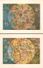

The Panorama of Today in Northern California its resources, activities and opportunities. / The Pageant of History in Northern California its colorful and adventurous beginnings.
Vivid Depiction of the Bay Area's Past and Present.
- Digital Map Information
- Suitable for large format printing
- Full resolution TIFF file
- ICC color profile embedded
- Delivered instantly via download link
Vivid Depiction of the Bay Area's Past and Present.
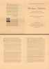
This is a richly illustrated c. 1950 set of two pictorial maps of Northern California prepared by artist Millard Sheets and commissioned by the American Trust Company. They are accompanied here by a booklet that explains the conception of the two works as celebrating 'the spirit and the achievement of the peoples living in the great circle of lands surrounding San Francisco Bay.'A Closer Look
The first map, the 'Panorama of Today,' highlights the wide variety of economic and leisure activities in the San Francisco Bay region. Stretching from Sonoma County to the Monterey Peninsula and inland to the Sierra Nevada, this map illustrates the varied industrial and commercial economy of Northern California, from fishing along the coast to viticulture in Napa and Sonoma Counties, to heavy industry in Oakland, and to livestock raising further inland. Leisure activities are also depicted, including beachgoers near Santa Cruz, a golfer on the Monterey Peninsula, and campers and skiers in the mountains at right. Finally, natural scenes of birds and other wildlife appear, along with landmarks such as the State Capitol in Sacramento.The second map, the 'Pageant of History,' provides an overview of the early history of the region, from its indigenous inhabitants through the gold rush and beyond. Covering the same territory as the 'Panorama', it is replete with historical allusions. At the top is Fort Ross, a Russian trading post in today's Sonoma County, and the Sonoma Barracks, site of the 1846 Bear Flag Revolt. Less than a month after the revolt, U.S. Marines captured Monterey, depicted near the bottom, as part of the Mexican-American War. Further inland are scenes depicting dancing Native Americans, Spanish friars and conquistadores, vaqueros wrangling cattle, the California Gold Rush, the arrival of railroads, battles between settlers and Native Americans, a stagecoach robbery, the dispensation of frontier justice, and bucolic depictions of trees and animals.
Publication History and Census
These maps, originally prepared as paintings, were drawn by Millard Sheets around the year 1950 and printed by lithogravure for the American Trust Company. The photographer Ansel Adams was also commissioned by the company to produce a similarly-titled book of photographs, The pageant of history and the panorama of today in northern California: a photographic interpretation. The maps are often cataloged separately, and several institutions hold one or the other, while the pair is held by the David Rumsey Historical Map Collection, the University of California, Berkeley, and the University of Illinois at Urbana-Champaign. (The OCLC includes the University of California, Los Angeles, but their own catalog only indicates one map.) The accompanying information booklet is especially rare, held by only UC-Berkeley and the University of Illinois.Cartographer
Millard Owen Sheets (June 24, 1907 - March 31, 1989) was an American artist and designer best known for his watercolors and murals. Born in Southern California, he attended the Chouinard Art Institute and was a student of Frank Tolles Chamberlin and Clarence Hinkle. Even before graduating, he was highly regarded for his watercolors and his work was soon displayed all over the country. During the Great Depression, he was a leading figure in the Public Works of Art Project, and during the Second World War, he spent time in South Asia as an artist-correspondent. During the 1930s-1940s, he increasingly took up large-scale mural projects, including mosaic murals. He also worked in bronze sculpture and stained glass, and also produced architectural designs. His works are strongly influenced by Realism, taking working and oppressed peoples as their subject, and bear some resemblance to other celebrated artists of the era, such as Diego Rivera. Sheets is considered one of the founders of California Scene Painting. Further Details...
Condition
Very good. Each map measures 19 x 24.5 in.
References
Individually listed - Rumsey 8080.000 / 8081.000. OCLC 24181008.