
1896 E.P. Noll Cycling Map of Philadelphia, Pennsylvania, and Vicinity

This item has been sold.
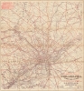
Noll's New Road, Driving and Bicycle Map of Philadelphia and Surrounding Country.
Hop on your bike and explore the world around you!
- Digital Map Information
- Suitable for large format printing
- Full resolution TIFF file
- ICC color profile embedded
- Delivered instantly via download link
Hop on your bike and explore the world around you!
This is a visually compelling 1896 E.P. Noll and Company map of Philadelphia and environs. The map was published to capitalize on the late-19th-century Philadelphia cycling craze at its apex. Philadelphia's relatively level terrain made it ideal for cycling, and maps like this opened the region to velocipedic exploration. It addressed a practical obstacle to recreational touring: finding usable routes through a road system of uneven quality. Noll combined this route selection with detailed local geography, allowing riders to plan excursions through a landscape of suburban villages, country hotels, mills, and railway stations.A Closer Look
With Philadelphia at the center, the map depicts the region from Fortuna south to Woodbury and from Centreville to Langhorne. Red overprinting highlights cycling roads throughout, emphasizing the popularity of this emerging new pastime. Concentric circles emanating from central Philadelphia help riders estimate the distance a potential excursion would cover. Other roads, railroads, rivers, and creeks appear as well. The map identifies towns, villages, train stations, and post offices throughout.The Bicycle Boom
Although invented in the early 19th century, bicycles only became commercially accessible and popular in the closing decades of the 19th century. A range of innovations made the machines more reliable, safe, comfortable, and affordable, and they became fashionable for transportation, leisure, and sport. As would later happen with automobiles, cycling clubs sprang up to scout the best routes, advocate for better roads (because not all roads were good for cycling), and connect enthusiasts. Cycling was particularly popular among women because it offered freedom of movement and association (the sexes could intermingle without parental oversight).Cycling in Philadelphia
Philadelphia was one of the centers of the Cycling Craze in the United States, with cycling clubs springing up throughout the city. These clubs even built elaborate clubhouses, including the Quaker City Wheelmen's, which still stands. The Wheelmen organized and hosted national meets, dances, and free public cycling events, and even attempted to print their own magazine, Cycling. The Quaker City Wheelmen reappeared in 1976 and still exist as 'QCW Cycling'.A year after this map's publication, a national cycling organization known as the League of American Wheelmen hosted an event in Philadelphia, attended by 45,000 cyclists. During the 1890s, when cycling was immensely popular in Philadelphia, publications such as the Philadelphia Inquirer published maps of cycling routes from 1896 to 1898 in a column titled, 'Trips Awheel: Where to Go and How to Get There'.
Publication History and Census
This map was created and published by E. P. Noll and Company in 1896. We note a single cataloged example, located at the University of California, Davis.Cartographer
Edward P. Noll (fl. 1882 - 1918) was an American map publisher and map mounter based in Philadelphia during the late 19th and early 20th centuries, trading as E. P. Noll and Company. His firm's publications included county landownership maps, real-estate atlases, urban street guides, and road maps for cyclists and motorists. The business was publishing by 1882, when it issued a landownership map of Floyd County, Indiana, demonstrating that its geographical interests extended beyond Pennsylvania. In Philadelphia, the firm described itself as map publishers and mounters and maintained premises at 17 North Sixth Street, an address appearing on its 1890 city guide map and its Atlas of Bucks Co., Penna of 1891. Its Philadelphia guide maps combined detailed street mapping with ward boundaries and other urban information. Noll also published folding maps of Philadelphia and the surrounding countryside for road travel, including maps expressly intended for bicyclists. By the early 20th century, the firm's road-map titles incorporated automobile travel, while its urban guide-map publishing continued with editions covering Philadelphia and Camden, New Jersey. A 1918 edition of the Philadelphia and Camden guide map documents the continued use of the E. P. Noll and Company imprint. Further Details...
Condition
Good. Wear and toning along original fold lines. Verso repairs and reinforcements at fold intersections. Slight loss at fold intersections.
References
OCLC 381174948.