
1975 Barstow Pictorial Historical Map of Providence, Rhode Island


The Historic East Side.
Unrecorded Historical Map of Providence.
$400.00
Choose a Collection:
This Item
Enquire
Unrecorded Historical Map of Providence.
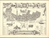
This is Marjorie Olson Barstow's 1975 historical pictorial map of Providence, Rhode Island, produced for the Historic East Side Association.A Closer Look
Oriented towards the northeast, this map focuses primarily on the East Side of Providence, east of the Providence River. More specifically, it illustrates several dozen historic structures, which are indexed in two keys at the bottom with their location and date of construction. Some of these buildings are illustrated in the top and bottom margins or along the edges. Prominent examples are University Hall at Brown University and the First Baptist Church (the congregation founded by Roger Williams in the 1630s), both of which were built on the eve of the American Revolution. Relatively modern structures from the 19th and 20th centuries also appear, including the Rhode Island State Capitol and, in the foreground, the Industrial National Bank Building (the tallest building in Rhode Island). Additional illustrations add character, including a clipper ship at the right and the elaborate cartouche at the bottom incorporating the city's seal.Publication History and Census
This map was drawn by Marjorie Olson Barstow in 1975 for the Historic East Side Association, a short-lived preservation organization (the contemporaneous Providence Preservation Society and East Providence Historical Society are still operational). We have been unable to locate any other examples of this map, either in institutional collections or on the market.Cartographer
Marjorie Olson Barstow (November 6, 1935 - July 21, 2020) was a Rhode Island-based artist and illustrator. Born in Worcester, Massachusetts, she graduated from the prestigious Rhode Island School of Design in 1956 and went on to a career as an illustrator for the City of Providence Planning Committee and The Providence Journal. Barstow also designed and built her own home on Lake Lashaway in southern Massachusetts. Further Details...
Condition
Very good. Light edge wear.