
1941 Chamber of Commerce Pictorial Map of St. Johns County, Florida

This item has been sold.
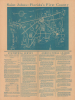
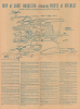
Saint Johns - Florida's First County. / Map of St. Augustine showing Points of Interest.
Florida's Oldest County.
Choose a Collection:
- Digital Map Information
- Suitable for large format printing
- Full resolution TIFF file
- ICC color profile embedded
- Delivered instantly via download link
This Item
Enquire
Florida's Oldest County.
This is a whimsical c. 1941 pictorial map of Saint Johns County, Florida, and the county seat, Saint Augustine, issued by the local Chamber of Commerce. It promotes the area's agricultural potential and tourist attractions, mainstays of the regional economy.A Closer Look
The recto includes a blueprint-style pictorial map of Saint Johns County, recording towns, roads, railways, and waterways. Illustrations throughout refer to local history, recreational activities, and agricultural and aquacultural products. Below the map is promotional text on the county's attractions for potential residents and businesses (schools, hospitals, parks, beaches, etc.), with a large section focusing on the area's agricultural productivity and further potential. The verso map covers Saint Augustine, noting streets, hotels and guesthouses, historic sites, public institutions, and attractions. These are also described in text below the map.Marine Studios and Marineland
Aside from early Spanish historical sites, one notable location is 'Marine Studios' in the recently incorporated community of Marineland, which was created by a group of grandees with ties to Hollywood and an enthusiasm for nature as the world's first underwater film studio. It quickly became popular with the wider public and was credibly billed as the world's first oceanarium, influencing later operations like SeaWorld. The oceanarium/film studio quickly expanded and became synonymous with the surrounding town of Marineland, though in the late 20th century it suffered from aging facilities and declining visitor numbers. After suffering heavy damage in Hurricanes Floyd and Irene in 1999, the park was reduced to its original 1938 structures (seen here), which were then renovated.Publication History and Census
This sheet was issued by the Saint Johns County Chamber of Commerce. It is undated, but statistics are given for 1940 and 1941, suggesting a publication date of 1941 or 1942. The recto map is signed by an artist named Sam Hubbard, likely Samuel Richardson Hubbard (1912 - 2002), who was born and raised in St. Augustine and is listed as a government draughtsman (working in Cobb County, Georgia) in the 1950 federal census. The verso map is signed by 'S.R.B.' This map is recorded in the OCLC among the holdings of the State Library of Florida, the Jacksonville Public Library, the University of Illinois at Urbana-Champaign, and the University of Wisconsin-Milwaukee.Condition
Very good. Newsprint. Even toning.
References
OCLC 70715824, 942690532, 44250662.