
1932 Payne / Thomas Bros. Survey Map of San Bernardino County, California

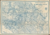
Settler's and miner's map of San Bernardino County California.
Mojave Mines.
- Digital Map Information
- Suitable for large format printing
- File Size: 62.98 MB
- File Type: ZIP / TIFF
- ICC color profile embedded
- Delivered instantly via download link
Mojave Mines.
A scarce, large-format 1932 James H. Payne map of San Bernardino County, California, published by Thomas Brothers. True to its title, it particularly highlights mines, water sources, and railroads.A Closer Look
Coverage includes San Bernardino County, with portions of Inyo, Tulare, Kern, Los Angeles, Orange, Riverside, San Diego, and Imperial Counties (with a small sliver of Ventura County at left), as well as small portions of Nevada and Arizona. Much of the area is divided colloquially between the 'High Desert' (roughly the central portion of the map between Antelope Valley and Yucca Valley) and the 'Low Desert' (the bottom portion of the map, including the Coachella Valley to the Lower Colorado River Valley around Blythe). The upper-right portion of the map is the heart of the Mojave Desert, heading towards Death Valley and Las Vegas.Survey lines crisscross the map, along with railroads, 'wagon roads,' irrigation works (including the L.A. Aqueduct) and other features. Springs, wells, mines, waterways, and other information relevant to settlers (especially farmers) and miners are noted throughout, often with colorful names like Last Chance (Springs), Horse Thief Springs, and Confidence Mine. Several placenames retain older renderings and spellings, such as 'Palm Spring' for Palm Springs and 'Appleton Valley' for Apple Valley.
Mines, Railroads, and Wagon Roads
References to borax, silver, gold, tin, and other mines abound, especially in the Mojave Desert. The many railroads cutting through the desert often had an economic function tied to the mines, with narrow-gauge branch lines connecting mines to the main line. Until mines and railroads penetrated the region in the late 19th century, the area was considered nearly uninhabitable, especially outside of valleys where seasonal rivers might run. In the following decades, the rights of way obtained by the railroads were often repurposed for building highways.Publication History and Census
This map is copyrighted to James H. Payne and is dated 1932. It was published by Thomas Brothers. The map is rare, only being listed among the institutional holdings of the University of California Berkeley and the University of California Riverside. No known market history.Cartographers
James Henry Payne (1870 - c. 1935) was a Los Angeles-based civil engineer and cartographer who collaborated with some of the major map publishers of the era, including Rand McNally and Thomas Brothers. According to census records, Payne was born in Illinois in 1870 and appears to have begun his career as a railroad surveyor, initially for the Choctaw, Oklahoma and Gulf Railroad and then for railroads in Southern California, where he had relocated by 1907. Even when working with larger map publishers like Rand McNally, Payne's maps generally resembled survey maps, with survey lines and blue line print, giving them a distinctive style. Further Details...
Thomas Brothers (1915 – 1999) was a prominent California-based English-American publisher specializing in maps and guidebooks. Founded in Oakland in 1915 by George Copeland Thomas, Guilbert Thomas, and Leonard Thomas, the company began modestly, selling maps of movie stars' homes from a Hollywood street corner, before developing into a major cartographic and guidebook publisher. Following George Thomas's death in 1955, his widow retained attorney Warren Wilson to organize the company's affairs. When none of the Thomas heirs expressed interest in continuing the business, Wilson and accountant Tom Tripodic purchased it, preserving the Thomas Brothers tradition while pursuing a new direction and eventually relocating the company's headquarters from San Francisco to Irvine, California. The firm prospered under Tripodic, growing to more than 200 employees and dominating the West Coast map market. Rand McNally acquired Thomas Brothers in 1999, laid off many of its experienced cartographers and employees in 2003, and closed the company's remaining California operations in 2009. Further Details...
Condition
Very good. Light wear along original folds. Several small tears along border professionally repaired. Several pencil and pen markings.
References
OCLC 25067961.