
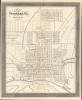
1868 Hogg City Plan or Map of Savannah, Georgia

This item has been sold.
Map of the City of Savannah, Ga.
Savannah in the Early Reconstruction Era.
- Digital Map Information
- Suitable for large format printing
- File Size: 5.87 MB
- File Type: ZIP / TIFF
- ICC color profile embedded
- Delivered instantly via download link
Savannah in the Early Reconstruction Era.
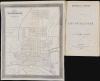
This is an absorbing 1868 John B. Hogg map of the city of Savannah, Georgia, which appeared in the first edition of the accompanying book Historical Record of the City of Savannah. Produced in the wake of the U.S. Civil War (1861 - 1865), the map reflects the city's efforts to reinvent itself for a new age.A Closer Look
This map is oriented towards the southwest, with the Savannah River at the bottom. Streets are labeled throughout, along with railroads, associated railroad facilities (depots, shops), a water works, cemeteries, parks, gardens, various city wards, squares, and public institutions like the police barracks. Aside from the Savannah River, a city pond, and a canal at the right, smaller waterways are ghosted in at the left and the top-right; Hogg, being City Surveyor at this time, would have been more knowledgeable than anyone about such underlying features of the city's geography.Unsurprisingly, as Savannah had so recently been a major center of the slave trade, racism is inscribed in the city's geography. Although Savannah itself had a small but long-established community of Freedmen, many being active Abolitionists working at the heart of the slave trade, most of the city's free Black population lived beyond city limits, in the area marked Dillontown. Later, an adjacent tract between Dillontown and the Laurel Grove Cemetery also developed and was known as Brownville, which, along with the Midtown neighborhood to the east (left here), grew to house newly freed Black Savannahians after the Civil War. After this map's publication in 1886, both Dillontown and Brownville were annexed by the City of Savannah and are today known as Cuyler-Brownville or Cuyler-Brownsville, where many historic buildings have been preserved.
Historical Context
This map was produced in the wake of the destructive U.S. Civil War. Savannah was the culmination of Sherman's March to the Sea, but the city itself was not severely damaged or destroyed, unlike several other large Southern cities. Despite a sizable Confederate garrison, Sherman had effectively besieged the town and was prepared to destroy or starve it into submission, but the Confederate commander, William J. Hardee, escaped across flooded fields using a makeshift pontoon bridge. Sherman decided not to pursue Hardee's forces for fear of overextending his army, but was able to deliver Savannah as a 'Christmas gift' to President Lincoln on December 21, 1864.Savannah, along with Charleston, South Carolina, had been the main entry point for captives from West Africa reaching the American colonies and, after 1776, the new states of the American Republic. Even after the international slave trade was suppressed in the early 19th century, illicit shipments of enslaved people from Africa and the Caribbean to Savannah remained common right up until the eve of the Civil War. Moreover, Savannah remained one of the most active markets for the domestic slave trade and was the site of the infamous March 1859 slave auction known as 'the Weeping Time,' the largest single slave auction in U.S. history.
After the war, like much of the South, Savannah struggled with food and material shortages. The end of slavery knocked out one of the pillars of the city's economy, but the revival of cotton and other industries (using exploitative labor only marginally better than slavery) and the further development of railroads helped to boost the city's economy. Culturally, Savannah built on the foundations of the Antebellum society of Freedmen in the city and emerged as one of the great centers of African-American religious, intellectual, and economic life in the South, despite significant legal and social barriers.
Publication History and Census
This map was prepared by John B. Hogg and printed by R. H. Howell in 1868. It is noted as being 'Photo' by D. J. Ryan; the meaning of this is unclear, but this may be a reference to early photolithography, perhaps capturing a larger survey map produced by Hogg. This map appeared in the first edition (1869) of the book Historical Record of the City of Savannah by F. D. Lee and J. L. Agnew, a fascinating retrospective of the city's history written just after the Civil War. This edition of the map is independently cataloged only at the Newberry Library and the University of Georgia (the OCLC notes five institutions, but the listing, 497830046, co-mingles multiple editions), while the entire book is more widespread.Cartographers
John Bowles Hogg (September 4, 1826 - March 26, 1888), also known as John Bowles Howard, was a civil engineer and architect active in Savannah, Georgia in the mid-late 19th century. Hogg was born in Beauford, South Carolina, where his father served as a Baptist deacon. He studied under architect Thomas Ustick Walter (1804 - 1887) and in 1848 designed his first prominent building, Trinity Methodist Church in Savannah's Telfair Square. He was elected City Surveyor in 1855 and held the role for much of the rest of his life. On the eve of the U.S. Civil War, Hogg was established as perhaps the leading civil engineer in Savannah, had married Georgia R. Lothropp (1830 - 1896), and had at least five children (several more would follow, though not all would survive into adulthood). According the Slave Schedule of the 1860 federal census, Hogg also owned five slaves, suggesting a degree of affluence. Hogg almost certainly fought in the U.S. Civil War (virtually all adult males in Savannah joined or were drafted into Confederate forces). A John B. Hogg appears in records as fighting with the Georgia cavalry before being captured and then pensioned in 1864, but this may indicate a different John B. Hogg from Georgia. In any event, after the war Hogg continued his work as City Surveyor and also designed a new sanctuary of the First Bryan Baptist Church, a curious choice for a former slave owner. This congregation had been founded by freed slave Andrew Bryan in 1788 and was one of the earliest Black Baptist churches in America (the wartime minister of this church, Garrison Frazier, had a fateful meeting with Gen. Sherman soon after the city's capture, in which the latter set aside 'forty acres and a mule' for settling Freedmen on the Sea Islands of South Carolina and Georgia). Hogg designed the congregation's new church (built in 1873) on a pro bono basis. For reasons that are unclear, Hogg changed his last name to Howard in 1879, when he was 54 years old. Further Details...
Richard H. Howell (c. 1821 - 1870) was an engraver, lithographic printer, and plate printer active in Savannah, Georgia. Howell was born in New York around 1821. It is unclear where he trained in engraving, but he was active in Georgia as early as 1853, when he produced Vincent’s Subdivision Map of the City of Atlanta. Though he advertised a wide range of services, including calling cards, professional cards, portraits, views, and so on, his works that have become best known to posterity deal with the U.S. Civil War. In the days leading up to the conflict, Howell printed a view drawn by Henry Cleenewerck titled The first flag of independence raised in the South, by the citizens of Savannah, Ga. November 8th, 1860. During the war, in 1861, he printed a very rare Confederate-produced Map of the Seat of the War, prepared by civil engineer Miller B. Grant and published by T. A. Burke. Howell also printed Confederate currency (which confusingly were issued by the CSA as a whole, the individual states, and by banks, though Howell appears to have primarily printed Georgia state notes). Further Details...
Daniel J. Ryan (c. 1833 - 1900) was a Savannah, Georgia-based photographer working mostly in stereoscopic photography. Ryan issued a range of souvenir photographs including portraits of Confederate generals (taken after the war) and, as his advertisements put it 'a large assortment of Negro Groups, Cotton Fields, etc…. Florida and Georgia Scenery…Yosemite Valley and Niagara Falls and full views of all Countries of the Globe.' He was best known for his series of 'Southern Stereoscopic Views' depicting rural life in the Reconstruction period. Ryan maintained a building and studio on Bay St. on the Savannah River waterfront, and later relocated to nearby Congress St. Little is known about Ryan's biography aside from his being born in Ireland and becoming a naturalized U.S. citizen in 1856. The 1880 federal census notes him as being married to an English-born wife named Clara but with no children. Ryan disappears from Savannah city directories and other records after 1897. Further Details...
Source
Lee, F. and Agnew, J, Historical Record of the City of Savannah, (Savannah, Georgia: J. H. Estille) 1869.
Condition
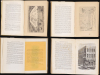
Good. Some archival verso repairs to old fold splits. Accompanies original illustrated volume, with deaccession stamps from the Georgia State Library. Book is foxed throughout with missing spine.
References
OCLC 497830046 (co-mingles multiple editions). Harris, L. and Berry, D. (eds.), Slavery and Freedom in Savannah (Athens, GA: University of Georgia Press) 2014.