
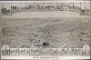
1883 C. J. Corbin Bird's-Eye View Map of Seneca Falls, New York

This item has been sold.
Seneca Falls, New York, 1882. Looking North-West.
Possibly the only surviving example of this view.
Choose a Collection:
- Digital Map Information
- Suitable for large format printing
- File Size: 242.05 MB
- File Type: ZIP / TIFF
- ICC color profile embedded
- Delivered instantly via download link
This Item
Enquire
Possibly the only surviving example of this view.
A striking, rare 1883 Philadelphia Publishing House / J. C. Corbin bird's-eye view of Seneca Falls, New York. The view presents the town in the midst of its 19th-century boom as a mill town. The work is unrecorded, and this may be the sole surviving example.A Closer Look
From a high-oblique perspective, the view looks northwest on the town of Seneca Falls, NY, straddling the Seneca River, flowing west to east from the left of the map towards the right. Seneca Falls is mainly famous for its prominence in the Women's Rights Movement: it was home to the 1848 Seneca Falls Women's Rights Convention, and its organizer, Elizabeth Cady Stanton, lived and worked in the town from 1847 to 1863. The view here focuses on the mills and factories, and their proprietors. By the middle of the century, Seneca Falls was among the largest flour milling towns in the world. Across the top and bottom of the view are depictions of the town's important structures: churches and a convent, factories and mills, the town's best hotel, and the houses of a dozen of Seneca Falls' prominent citizens.Despite the factories along the river, the town is clearly not a dense eastern city: south of the Seneca River and north of the railroad tracks, houses are generously spaced, with lots of newly-planted trees and spacious lawns.
American Bird's-Eye City Views
The Bird's-Eye view industry emerged in the United States in the middle part of the 19th century and coincided with the commercial development of lithographic printing. Before the rise of lithography, the ability to own and display artwork in the home was largely limited to the extremely wealthy, but the advent of lithographic printing made it possible for everyone to own visually striking artwork. A robust trade developed in portraits of political leaders, allegorical and religious images, and city views.City views were being produced in the United States as early as the 1830s, but the genre exploded after the American Civil War (1861 - 1865). Bridging the gap between maps and pictures, most 19th-century American bird's-eye views presented cities to the public from high points. Some were imagined, but others were drawn from hot-air balloons or nearby hills. The presentation, combining high elevation, commercial interest, and new printing technology, created a uniquely American art form, as described by historian Donald Karshan,
Some print connoisseurs believe that it was only with the advent of the full-blown city-view lithograph that American printmaking reached its first plateau of originality, making a historical contribution to the graphic arts. They cite the differences between the European city-view prints and the expansive American version that reflects a new land and a new attitude toward the land.The vogue for bird's-eye city views lasted from about 1845 to 1920, during which period some 2,400 cities were thus portrayed, some multiple times. Although views were produced in many urban centers, the nexus of view production in the United States was Milwaukee, Wisconsin. The major American viewmakers were Stoner, Wellge, Bailey, Fowler, Hill Ruger, Koch, Burleigh, Norris, and Morse, among others.
Publication History and Census
This view is unsigned, but may be the work of landscape artist Charles Lewis Fussell (1840 - 1909), who collaborated with Corbin on a number of other views (c.f. Corbin / Fussell view of New Brighton, Pa, also published in 1883, and Adams, Massachusetts in 1882). This view was published by C. J. Corbin and the Philadelphia Publishing Company in 1882. It is rare and does not appear in Reps' comprehensive catalog Views and Viewmakers of Urban America (University of Missouri, Columbia, 1984). We see no examples listed in OCLC.Cartographer
C. J. Corbin (fl. c. 1870 - 1890) was a Philadelphia-based view publisher active in the late 19th century. Most of his work focuses on Pennsylvania, where he worked at 923 Chestnut Street. He issued several views by William Wallace Denslow. Until about 1880, he published a C. J. Corbin and Company, after which he published under the Philadelphia Publishing House, which he appears to have managed. He remained active until about 1890. Further Details...
Condition
Good. Few surface tears, neatly mended with virtually no loss.
References
Not in OCLC, Not in Reps.