
1988 City Design Pictorial View of Sausalito, Tiburon, and Environs, California

Yachts and Ewoks.
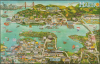
This is a rare 1988 pictorial view of Sausalito, Tiburon, and environs in southern Marin County, California, prepared by the firm City Design. While primarily intended to promote local businesses, the view also celebrates the area's culture and history, particularly its maritime connections and magnificent bayside views.A Closer Look
The view is oriented towards the southwest, with Tiburon in the foreground, Sausalito towards the top, and the Golden Gate Bridge and San Francisco in the background at left. Aside from Sausalito and Tiburon, other nearby communities such as Strawberry and Mill Valley are also identified. Major roads are labeled, including U.S. Highway 101, which passes through the Waldo Tunnel (also known as the Rainbow Tunnel and now officially the Robin Williams Tunnel, after the actor and comedian who was from the area) at the top and then proceeds to the Golden Gate Bridge. Local businesses and institutions are identified, with illustrations of their owners. Many of these no longer exist, but a handful remain, including historic institutions and businesses such as the Corinthian Yacht Club and Sam's Anchor Cafe. Scrolls and speech bubbles give information on local history and culture throughout.The view contains some comical elements as well, such as Al Capone imprisoned on Alcatraz Island, King Kong atop the Transamerica Pyramid, and an octopus tentacle reaching on the Richardson Bay Freeway Bridge, the portion of the U.S. 101 linking Sausalito with Tiburon. At the top-right below the compass, are some Ewoks (whose home world of Endor was inspired by the redwood forests of northern California) and an AT-AT Walker from the Star Wars film franchise, a reference to the prominence of Lucasfilm and other local ventures of George Lucas, whose 'Skywalker Ranch' lies to the northwest of the area seen here.
Publication History and Census
This map was prepared in 1988 by the firm City Design, based in nearby Pleasanton, California. A raft near Alcatraz Island depicts the artists as escaped convicts from Alcatraz. This map is scarce, with no known institutional holdings and minimal market history. We are only aware of two other examples, both of which are trimmed to the neatline, as here.Cartographers
City Design (c. 1976 - 1997) was a Pleasanton, California-based firm that produced promotional pictorial views of American cities, particularly in the San Francisco Bay Area. It originated as an offshoot of the Canadian firm Archar Inc., which was a prolific creator of city views in the 1970s and early 1980s. City Design appears to have become independent of Archar and was most active in the late 1980s and early 1990s, with its last cataloged map being a view and calendar of Silicon Valley in 1997 (Rumsey 10640.000). Late in the company's life, it relocated to San Ramon, California. Further Details...
Archar / Travel Graphics (1973 - Present) is a Canadian and U.S. publishing company initially based in Toronto, Ontario. The firm is best known for its 'City Character Prints' - cartoonish view style maps intended to express the 'character' of a city. The firm employed a host of in house art directors, as well as a host of freelance illustrators. We find no trace of the company after 1983. Variants of the imprint include 'Archer Western' based in British Columbia and the St. Paul, Minnesota based 'Archar International'. Around 1984, the Minnesota firm was renamed Travel Graphics - Archer International, often printing under the 'Travel Graphics' imprint. Travel Graphics later relocated to Hawaii, where they remain active. Further Details...
Condition
Very good. Trimmed to neatline.