
1907 Walker Pocket Map of Southern New Hampshire, Lakes Region

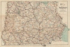
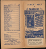
Map of New Hampshire Southern Part / Latest Map of Southern New Hampshire.
New Hampshire's Lakes Region.
- Digital Map Information
- Suitable for large format printing
- Full resolution TIFF file
- ICC color profile embedded
- Delivered instantly via download link
New Hampshire's Lakes Region.
This is a scarce c. 1907 George Walker pocket map of southern New Hampshire, including much of the state's gorgeous Lakes Region. It was produced during a period of heightened tourism to the Lakes Region and the White Mountains, facilitated by the development of railroads and the expansion of the state's tourism economy.A Closer Look
Coverage includes the southern portion of New Hampshire (Cheshire, Hillsborough, Rockingham, Strafford, Merrimack, and Sullivan Counties) as far north as Lake Winnipesaukee (here spelled as Winnipiseogee), along with portions of Vermont, Massachusetts, and Maine. Township borders are traced throughout, along with railroads, roads ('best routes' traced in red), post offices, and waterways, including the dozens of lakes, including Squam Lake, that dot the southern part of the state. Mountains and hills are labeled with elevations noted. The Atlantic coast appears at bottom-right around Portsmouth, the state's only deep-water port. Then as now, the southern part of New Hampshire was more populated than the White Mountains and North Country, with the cities of Manchester, Nashua, Dover, and Concord standing out prominently here.Picturesque Summertime Scenery
In the late 19th century, aided by the expansion of railroads, New Hampshire's Lakes Region began attracting wealthy families from Boston, New York, and other urban centers seeking escape from the summer heat. Early 'rusticators' gave way to travelers seeking more private and pleasant accommodations, and many families began to build cottages and camps along the banks of the lakes. As Lake Winnipesaukee became the preferred destination of summertime seasonal residents and tourists, those seeking more serene and isolated surroundings moved on to Lake Sunapee and other nearby lakes. A tourism economy developed around these travelers, including steamboats and restaurants.Publication History and Census
This map was prepared by George Walker and Co. around the turn of the 20th century. It is undated, and from the features present could date from anywhere between 1893 to 1908. The list of automobile maps on the cover and the address given for the company (400 Newbury St., its home from 1907 if not earlier, as opposed to the earlier 60 Tremont St.) would suggest a date closer to 1908. It is worth noting that this particular example was purchased in Boston at the famed Old Corner Bookstore, the original building of which is still extant, though no longer operating as a bookstore.Due to uncertainty over the publication date, the co-mingling of physical and digital examples in catalog listings, and the map's being variously cataloged by the title on the map itself versus the cover title, the cataloging of this map is not entirely consistent. The 1908 dated edition of the map is listed among the holdings of 7 institutions in the OCLC as well as the New Hampshire Historical Society.
Cartographer
George Hiram Walker (January 4, 1852 - November 14, 1927) was a Boston based publisher of books, views, and maps active in the late 19th and early 20th centuries. Born in Springfield, Vermont, Walker started his life as a dry goods merchant but developed an active interest in publishing during the early 1870s. Walker began publishing in 1878 when he partnered with an unknown New York Firm. Two years later, Walker brought the operation in house by partnering with his brother, Oscar W. Walker, in the opening of a lithography studio at 81 Milk Street, Boston. Shortly thereafter the firm expanded to new offices at 160 Tremont Street, Boston. The Walker brothers produced a large corpus of works, most of which focused on travel and tourism in New England. Walker also established the Walker-Gordon Milk Laboratory with Dr. Thomas Morgan Rotch and Gustave Gordon. This interesting investment was based on the premise that infant deaths could be avoided by providing higher quality milk. The company eventually became a great success, producing a high-quality cow milk that closely resembled human breast milk. In the process the Walker-Gordon laboratory developed many of the dairy health standards that are still with us today. Walker married Irene L. Loud on March 25, 1885. Further Details...
Condition
Very good. Some transference. Wear and reverse stabilization along some fold lines, including some minor stabilized splits. Minor discoloration where originally attached to binder. Accompanies original paper binder.
References
OCLC 999541311 (1908 ed.)