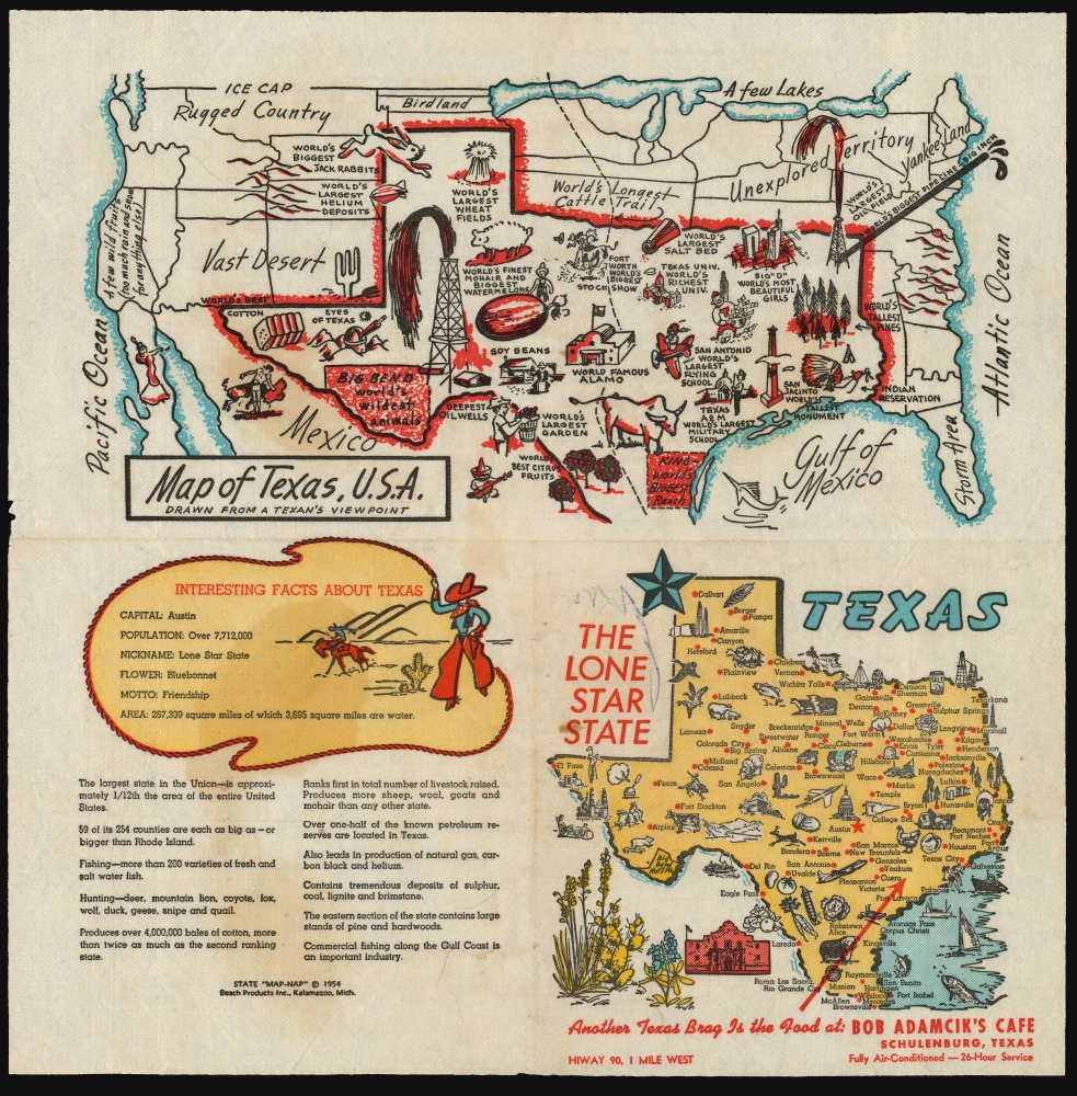
This is a 1954, 'Map-Nap' of the state of Texas, featuring a map of the United States from the perspective of a Texan. This colorful map, printed on a napkin, marks principal cities, and is decorated pictorially with icons of the via Texana: The Alamo, the monument of San Jacinto, spouting oil wells, and other such elements. The 'Map of Texas, U.S.A.,' in particular, features an array of classically Texan attractions: the largest flying school, the largest garden, the biggest ranch, the wildest animals, the largest salt bed, the most beautiful girls, the tallest pines, the biggest jackrabbits. And so on. A list of 'Interesting Facts About Texas' offers information of the state's size, population, produce, and industry. (For example, the reader learns that Texas is 'The largest state in the Union... approximately 1/12the the area of the entire United States.')
A Full Series?
Beach Products appears to have produced this piece of Texana as part of a series of 'State Map-Naps.' We are aware of examples not only dedicated to Texas, but also for Florida, Indiana, Michigan, California, North Dakota, and Minnesota. While it would be reasonable to assume a plan to produce a 'Map Nap' for every state in the Union, relatively few have appeared on the market, and it may be that the project was cut short.Publication History and Census
This map was printed by Beach Products Inc. of Kalamazoo, Michigan, having been copyrighted in 1954. (Beach Products were a paper goods company less known for their maps and more for their napkins.) We see no examples of the Texas Map-Nap in OCLC, but there is a single listing for another in the series (Michigan: Water Wonderland) in the collection of the Library of Michigan.
Cartographer
Beach Products, Inc. (1940s - 1960s) was an American paper goods company based in Kalamazoo, Michigan. Incorporated in 1941 and running a factory employing 50 workers, they appear to have focused primarily on printed napkins, paper plates, and cups, on a variety of themes (a 1957 advertisement touts such seasonal themes as 'Pumpkin Designs' and 'Singing Cats.' Between 1954 and 1956, their offerings included a series of state maps, printed to both full size dinner napkins and smaller format cocktail napkins: these 'Map-Naps' featured a map of a given state on the forward fold, whilst the reverse fold contained an array of 'Interesting Facts' about the state portrayed. Some of these, notably the Map Nap dedicated to Texas, included further material, with all four folds containing entertaining content. While it would be natural to assume at least a plan to present a Map Nap for every state of the Union, we have identified only a handful to have survived. Given the purpose of the average napkin, it is only to be expected that these survive poorly, and it may be that many are lost to posterity. More by this mapmaker...
Fair. One mended tear; some pen marking on surface near title.