
1970 Pictorial Tourist Map of Florida

Visit Florida State Parks and Historic Memorials.
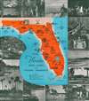
Highlights Florida's state parks and historic memorials.
$200.00
Choose a Collection:
This Item
Enquire
Highlights Florida's state parks and historic memorials.
This is a c. 1970 pictorial tourist map of Florida. Ringed by photographs of Florida attractions and activities, the map depicts the state from Alabama to the Atlantic Ocean and from Georgia and Alabama to Key West. Pictorial vignettes highlight state parks and historic memorials throughout the state, including the Florida Caverns, Manatee Springs, Turtle Mound, and Collier Seminole. A key to the left of Key West notes that four different symbols are used when marking sites around the state: circles mark parks that are in operation, squares mark partially developed parks, and triangles note undeveloped parks. Diamonds denote historic landmarks.Publication History
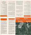
This map was published by the Florida Board of Parks and Historic Memorials c. 1970.Condition
Very good. Verso repair to a fold separation. Text on verso.