
Baarsel, Cornelis van

Cornelis van Baarsel (November 15, 1761 – August 17, 1826) was a Dutch engraver, cartographer, and draftsman active in Amsterdam during the late 18th and early 19th centuries. Baarsel was born in Utrecht, the son of Cornelis van Baarsel Sr., a grocer who subsequently moved his family to Amsterdam. Initially trained in his father's trade, he showed a greater aptitude for drawing than commerce. After unsuccessful employment in a cloth shop and an apothecary, he reportedly spent several years at sea before returning to Amsterdam to pursue an artistic career. In 1789, he married Dorothea Catharina Veelwaard (1758 - 1836), a member of an established Amsterdam family of engravers and copperplate printers. Encouraged by his wife's family, Van Baarsel established himself as an independent engraver in 1789, specializing in cartography. His workshop was probably located on the Haarlemmerdijk in Amsterdam. During the reign of Louis Bonaparte (1806 - 1810), King of Holland, Van Baarsel was appointed principal engraver at the military cartographic depot, working in Amsterdam and The Hague. Following Louis's abdication in 1810, he moved to Paris, where he continued engraving maps for the military authorities. He returned to Amsterdam in 1815 and resumed private commissions. Van Baarsel produced numerous maps of the Netherlands and its overseas possessions, collaborating with prominent publishers and engravers, including Cornelis Covens and P. N. Tuyn. He trained his son, Willem Cornelis van Baarsel (1791 - 1854), who joined the family workshop, with their collaborative engravings appearing under the imprint C. van Baarsel & Zoon from approximately 1817. Following Cornelis's death in Amsterdam on August 17, 1826, Willem Cornelis continued the engraving business under his own name.
References: Hofman-Allema, A. C., 'Veelwaard en Van Baarsel,' Caert-Thresoor, vol. 8, no. 1 (1989).
One of the first maps to depict Tasmania as a separate island.
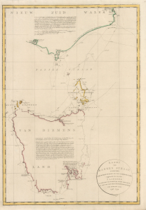
Kaart van Basses Straat Tusschen Nieuw Zuid Wales en Van Diemens-Land.
$2,300.00
Acquire
- Digital Map Information
- Suitable for large format printing
- Full resolution TIFF file
- ICC color profile embedded
- Delivered instantly via download link
This circa 1800 Dutch edition of Matthew Flinders' chart of Bass Strait and Van Diemen's Land records the surveys that helped establish Tasmania's insularity in European cartography and is among the first maps to depict Tasmania as a separate island. Engraved by Cornelis van Baarsel after the chart Aaron Arrowsmith published in 1800, it follows Flinders and George Bass through the strait and around Tasmania in the colonial sloop Norfolk. Its tracks, differentiated coastlines, and extensive Dutch annotations preserve both Flinders' achievements and the limitations of this reconnaissance, distinguishing surveyed shores from the vast stretches still imperfectly known. (more details)