
Litografía B. Baño

Litografía B. Baño (fl. c. 1930 – c. 1960) was a Barcelona based commercial lithography firm. The issued various posters for events and advertising as well as a several collections of trade cards. The firm seems to have been intimate with the chocolate industry, including Chocolates Orthi, Piera Y Brugueras and Chocolates Juncosa, who provided it with considerable business
An uncut example of a wonderfully charming pictorial map of North America.
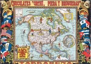
Mapa de America del Norte y Central, Razas y Fauna del Continente.
$600.00
Acquire
- Digital Map Information
- Suitable for large format printing
- File Size: 33.61 MB
- File Type: ZIP / TIFF
- ICC color profile embedded
- Delivered instantly via download link
A highly unusual c. 1940 Albert Albert Mestre i Moragas pictorial map of North America issued by Chocolates Orthi, Piera Y Brugueras of Tarragona, Spain. This beautiful pictorial map is an uncut sheet of 50 trading cards that were issued inside boxes of Spanish chocolates. Pictorial illustrations of indigenous Native Americans as well as regional fauna appear throughout. Mestre appears to have been largely unfamiliar with North America, placing alligators in the Great Lakes, bison north of the Hudson Bay, and anacondas in Mexico. A smaller sub map details the North Pole with a polar bear at center. Another small map in the upper right corner details the breakdown of cards. The map features an elaborate graphic surround with flags of various North American and Central American nations and the Chocolates Orthi, Piera Y Brugueras banner. (more details)
Intriguing advertising puzzle map of Africa.
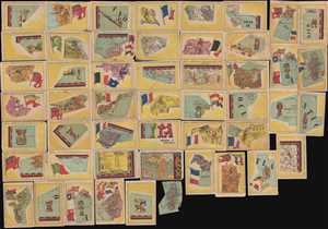
Mapa de Africa
$350.00
Acquire
- Digital Map Information
- Suitable for large format printing
- File Size: 10.05 MB
- File Type: ZIP / TIFF
- ICC color profile embedded
- Delivered instantly via download link
A highly unusual c. 1940 pictorial map of Africa issued by Chocolates Orthi, Piera Y Brugueras of Tarragona, Spain. This beautiful pictorial map is incomplete, composed of only 50 of the 60 unusually shaped trading cards that were issued inside boxes of Spanish ... (more details)