
Bouchet, Jean-Venant

Jean-Venant Bouchet (December 4, 1655 - 1732) was a Jesuit missionary active in South and Southeast Asia in the late 17th and early 18th centuries. Born in Fontenay-le-Comte (Vendée), he became a Jesuit novice in 1670. After his formation, he briefly was based in Siam in 1688 until missionaries were expelled that same year. Afterwards, he went to Pondicherry and the Jesuit Madurai Mission in southern India, a mission he would eventually lead for more than 20 years (1710 - 1732), though briefly returning to Rome to personally defend the accommodationist tactics of the Jesuits. These methods, established by Roberto de Nobili, led Bouchet and other Jesuits to adopt the dress and lifestyle of a Hindu sannyasin aesthetic in order to make inroads with the Brahminical elite. Bouchet was a polymath who recognized that European knowledge of Indian geography was largely based on outdated classical maps or vague maritime charts. He spent decades traveling through the interior of the Carnatic and Madurai regions, meticulously documenting the landscape. Bouchet's ethnographic and geographical reports provided the first truly detailed accounts of the inland territories of South India, moving beyond the coastline to describe the complex river systems, mountain ranges, and political boundaries of the Nayaka kingdoms. He later collaborated with royal cartographer Jean-Baptiste Bourguignon d'Anville, providing d'Anville with a wealth of data that allowed him to produce the 1737 'Carte de l'Inde,' which revolutionized European cartography of the subcontinent.
Among the Earliest Detailed European Maps of Southern India.
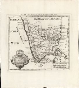
Sud-Theil von Indien Herwerts des Ganges.
$350.00
Acquire
- Digital Map Information
- Suitable for large format printing
- File Size: 8.03 MB
- File Type: ZIP / TIFF
- ICC color profile embedded
- Delivered instantly via download link
This is Jean-Venant Bouchet's c. 1728 map of southern India, published in Joseph Stöcklein's collection of missionary letters and accounts Allerhand so lehr-als geist-reiche Brief, Schrifften und Reis-Beschreibungen. It is among the earliest European maps to depict this part of the Subcontinent with reasonable accuracy. (more details)