
Bourgoin, Pierre

Pierre Bourgoin (???? - 17??) was a French line and letter engraver active in Paris in the early to mid-18th century. His is best known for engraving map for great French cartographer Jean-Baptiste Bourguignon d 'Anville (1697 - 1782).
Greatest map from Prevost's Voyages.
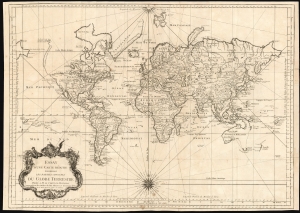
Essay d'une Carte Reduite, Contenant Les Parties Connuees du Globe Terrestre Dedié a M le Comte de Maurepas Commandeur des Ordres du Roy Ministre et Secretaire d'Etat.
$875.00
Acquire
- Digital Map Information
- Suitable for large format printing
- DPI: 600
- File Size: 75.08 MB
- File Type: ZIP / TIFF
- ICC color profile embedded
- Delivered instantly via download link
An attractive first edition, first plate example of J. N. Bellin's 1748 nautical chart of the world. Presents the entire world on a Mercator Projection based on a Paris (L'Isle de Fer) meridian. This is the first iteration of this important map, exhibiting a pre-Cook geography throughout, but most specifically in the Pacific and along the northwest coast of America.
North America to the west of the Mississippi is vaguely rendered according to 16th century expeditions into the region by Coronado, La Salle, De Soto, and others. Bellin identifies the semi-mythical civilizations of Quivira and Teguayo, both associated with legends of the Seven Cities of Gold, in what is modern day Utah, California, and Nevada. Along the western coast the strait discovered by the 17th-century explorer Martin Aguilar is noted. In a grand, optimistic vein, a great the River of the West (Fl. de l'Ouest) is shown extending from the Lake of the Woods (Lac de Bois) nearly to the Pacific. Via additional waterways, this river would have provided an easy link between the Pacific and the Great Lakes, and the Atlantic. The River of the West appeared in many 18th-century maps of the Americas and is reflective of French hopes for a water route from their colonies in Canada and Louisiana to the Pacific. Beyond here becomes extremely vague, with the notation in French 'Probably America extends as far as here.' The Aleutians are vaguely rendered according to various sightings by Vitus Jonassen Bering and Aleksei Chirikov: a note indicates that 'The Muscovites came here in 1743 but were stranded and drowned,' probably a reference to Bering and Chirikov's second Kamchatka expedition.
In the Pacific, various Polynesian Island groups are noted though many are slightly or significantly misplaced. The Solomon Islands are vastly oversized referencing the early 17th claims of Quiros. The other lands discovered and erroneously mapped by Quiros in 1606 and Davis in 1686 during their search of the Great Southern Continent are also noted. Hawaii, as yet undiscovered, is absent. New Zealand and Australia, (here labeled 'Nouvelle Holland,') are depicted mainly as per Abel Tasman's mid-16th century model, albeit the latter has part of its southern coastline ghosted and Van Diemen's Land (Tasmania) is attached to the mainland. New Guinea is connected to northeastern Australia. (more details)
North America to the west of the Mississippi is vaguely rendered according to 16th century expeditions into the region by Coronado, La Salle, De Soto, and others. Bellin identifies the semi-mythical civilizations of Quivira and Teguayo, both associated with legends of the Seven Cities of Gold, in what is modern day Utah, California, and Nevada. Along the western coast the strait discovered by the 17th-century explorer Martin Aguilar is noted. In a grand, optimistic vein, a great the River of the West (Fl. de l'Ouest) is shown extending from the Lake of the Woods (Lac de Bois) nearly to the Pacific. Via additional waterways, this river would have provided an easy link between the Pacific and the Great Lakes, and the Atlantic. The River of the West appeared in many 18th-century maps of the Americas and is reflective of French hopes for a water route from their colonies in Canada and Louisiana to the Pacific. Beyond here becomes extremely vague, with the notation in French 'Probably America extends as far as here.' The Aleutians are vaguely rendered according to various sightings by Vitus Jonassen Bering and Aleksei Chirikov: a note indicates that 'The Muscovites came here in 1743 but were stranded and drowned,' probably a reference to Bering and Chirikov's second Kamchatka expedition.
In the Pacific, various Polynesian Island groups are noted though many are slightly or significantly misplaced. The Solomon Islands are vastly oversized referencing the early 17th claims of Quiros. The other lands discovered and erroneously mapped by Quiros in 1606 and Davis in 1686 during their search of the Great Southern Continent are also noted. Hawaii, as yet undiscovered, is absent. New Zealand and Australia, (here labeled 'Nouvelle Holland,') are depicted mainly as per Abel Tasman's mid-16th century model, albeit the latter has part of its southern coastline ghosted and Van Diemen's Land (Tasmania) is attached to the mainland. New Guinea is connected to northeastern Australia. (more details)