
Cowley, William Ambrosia

William Ambrosia Cowley (fl. c. 1683 - 1686) was an English privateer and navigator notable for circumnavigating the globe and for producing the first map of the Galapagos Islands, drafted in 1684. A brief account of his travels appeared as 'Cowley's Voyage Round the Globe' in William Hacke's Collection of Original Voyages, published in 1699. He was also the originator of the phantom island of Pepys, supposedly some 230 nautical miles north of the Falkland Islands.
One of the earlist obtainalbe maps of the Galapagos.
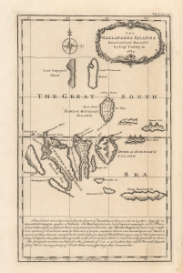
The Gallapagos Islands Discovered and Described by Capt. Cowley in 1684.
$1,250.00
Acquire
- Digital Map Information
- Suitable for large format printing
- Full resolution TIFF file
- ICC color profile embedded
- Delivered instantly via download link
This 1744 Emmanuel Bowen map of the Galápagos Islands is one of the earliest specific maps of the remote archipelago, later made famous by Charles Darwin and the voyage of HMS Beagle. Based on 1683 survey work by Captain William Ambrose Cowley, this is the first substantial English mapping of the Galápagos. This map represents a critical stage in the cartographic history of the Galápagos, being the definitive cartography of the islands until Darwin and FitzRoy's 1835 voyage. (more details)