
Créqui-Montfort, Henri Georges de
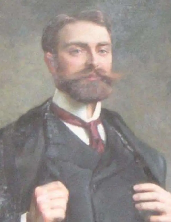
Henri Georges de Créqui-Montfort (September 27, 1877 – April 4, 1966) was a French explorer, anthropologist, diplomat, businessman, and sport shooter. He was born in Normandy to ballerina Eugénie Fiocre and the landowner and aristocrat Stanislas Le Compasseur de Créqui-Montfort Marquis de Courtivron. Little is known of his upbringing, although he had a full education and took degrees in literature and law. In 1896, he would be among those awarded the Drummond Castle medal, presented by the British Embassy on behalf of Queen Victoria for assisting in the rescue of the SS Drummond Castle on June 16, 1896 (mainly the rescue of bodies, since there were only three survivors of the sinking).
His contribution to the cartographic world appears to have been his role as Chef de la mission scientifique Française en Amérique du Sud between 1903-1904, to which he was assigned by the Ministry of Public Education. He surveyed and explored the Andean highlands with Eugène Sénéchal. With Argentine archaeologist Eric Boman, he discovered the pre-Inca site of Tastil. As part of the mission, he was ultimately responsible for the mission's archaeological excavations on a Tiahuanaco site. As part of his ethnographic and archaeological work, he brought numerous objects back to Paris with the aim of forming a future museum of Amerindian archeology in Paris. He would be awarded a gold medal by The Geographical Society in 1910.
During World War I, he served as infantry captain. In 1917, he was assigned to the High Commission of the French Republic in the United States, serving in Washington as aide-de-camp to General Henri Claudon, head of the French military mission responsible for training American troops. In 1919 he was awarded the Croix de guerre avec palmes. After the war, he served in various diplomatic roles in Canada and the United States. In 1953 he would be made Commandeur de la Légion d'Honneur.
Much of his history is obscured by his achievements as an Olympic sport shooter. He competed in the 1912 and 1924 Summer Olympics, both in clay pigeon shooting and the team 30-meter dueling pistol and the 25-meter rapid-fire pistol events.
His contribution to the cartographic world appears to have been his role as Chef de la mission scientifique Française en Amérique du Sud between 1903-1904, to which he was assigned by the Ministry of Public Education. He surveyed and explored the Andean highlands with Eugène Sénéchal. With Argentine archaeologist Eric Boman, he discovered the pre-Inca site of Tastil. As part of the mission, he was ultimately responsible for the mission's archaeological excavations on a Tiahuanaco site. As part of his ethnographic and archaeological work, he brought numerous objects back to Paris with the aim of forming a future museum of Amerindian archeology in Paris. He would be awarded a gold medal by The Geographical Society in 1910.
During World War I, he served as infantry captain. In 1917, he was assigned to the High Commission of the French Republic in the United States, serving in Washington as aide-de-camp to General Henri Claudon, head of the French military mission responsible for training American troops. In 1919 he was awarded the Croix de guerre avec palmes. After the war, he served in various diplomatic roles in Canada and the United States. In 1953 he would be made Commandeur de la Légion d'Honneur.
Much of his history is obscured by his achievements as an Olympic sport shooter. He competed in the 1912 and 1924 Summer Olympics, both in clay pigeon shooting and the team 30-meter dueling pistol and the 25-meter rapid-fire pistol events.
First Scientific Mapping of the Andes.
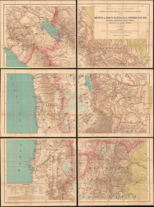
Régions des Hauts-Plateaux de l'Amérique du Sud (Bolivie, Argentine, Chili, Pérou) parcourues par la mission française. Carte dressée par V. Huot, d'après les travaux des membres de la mission, les sources originales inédites et les documents les plus récents.
$2,200.00
Acquire
- Digital Map Information
- Suitable for large format printing
- Full resolution TIFF file
- ICC color profile embedded
- Delivered instantly via download link
This is a scarce, monumental map of the South American highlands of Bolivia, Argentina, Chile, and Peru. The map was executed by the cartographer Victor Huot in 1905 based on extensive surveys performed by the 1903 - 1904 French Scientific Mission of Georges de Créqui-Montfort and anthropologist Eugene Sénéchal de la Grange. The Mission was multidisciplinary: in addition to its cartographic contributions, its members made forays into anthropology, linguistics, paleontology, and studies of the flora and fauna of the South American highlands. The survey was immediately hailed for the advances it represented in many fields. The map, in particular, was recognized as a foundational work: the Mission's surveys being the first scientific, firsthand mapping of the Andes. (more details)