
Croisey, Jean-Baptiste

Jean-Baptiste Croisey (c. 1740 - 1810) was a French Paris based engraver active from roughly 1760 through 1810. Little is known of his life and training. His earliest known work was for Jacques-Nicolas Bellin (1703 - 1772), chief Ingénieur Hydrographe at the French Dépôt des cartes et plans de la Marine until 1798. He also engraved for Louis Charles Desnos (1725 - 1805) from 1790 to 1792, and for Bruny d'Entrecasteaux in 1807, among other publishers.
From lost Russian sources.
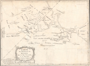
Carte des Découvertes des Russes dans la Mer Orientale, et en Amerique Pour Servir à L'essai, Sur le commerce de Russie.
$2,000.00
Acquire
- Digital Map Information
- Suitable for large format printing
- File Size: 378.74 MB
- File Type: ZIP / TIFF
- ICC color profile embedded
- Delivered instantly via download link
This is a rare and unusual 1777 map of the North Pacific in the vicinity of Alaska, the Bering Strait, and northeastern Siberia based upon Russian Promyshlenniki (trader) exploration. It appeared accompanying one of the earliest works on Russian commerce, the M. de Marbault's Essai sur le Commerce de Russie, avec l'Histoire de ses Decouvertes. (more details)