
Dietell, Christoph

Christoph Dietell (March 8, 1690 - December 1, 1764) was an Austrian copperplate and letter engraver, and art dealer, active in the 18th century. Dietell was born in Upper Palatinate, Bavaria but relocated to Vienna at a young age. His father, Stephan Dietl, was also a copper plate engraver. Christoph Dietell studied at the University of Vienna as a 'civis academicus' (historian), and did copperplate engraving for the university. By 1732 he was located in Graz, where he became known as a map and landscape engraver, which secured both secular and ecclesiastical business. He died in Graz in 1764. Franz Ambrosius Dietell, his brother, was also a noted Vienna copperplate engraver.
Jesuit Foothold in the Chuanshan Archipelago.
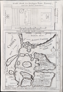
Land-Taffel der Insel Sanciano.
$750.00
Acquire
- Digital Map Information
- Suitable for large format printing
- File Size: 466.58 MB
- File Type: ZIP / TIFF
- ICC color profile embedded
- Delivered instantly via download link
This is the Joseph Stöcklein and Caspar Castner 1729 map of the south coast of China near Macau and Hong Kong. It highlights the Jesuit foothold on Shangchuan Island on the southern coast of Guangdong, China, dramatically overstating its size and proximity to Macao and Guangzhou, likely intentionally so that Stöcklein could incorporate additional detail. (more details)
Illustrates the Israelites crossing the Red Sea.
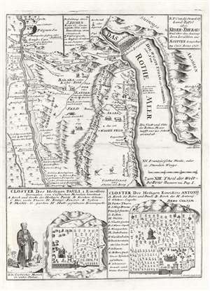
Land-Taffel über NIder-Thebais und über den Auszug deren Israëliten aus AEgypten.
$450.00
Acquire
- Digital Map Information
- Suitable for large format printing
- DPI: 600
- File Size: 11.42 MB
- File Type: ZIP / TIFF
- ICC color profile embedded
- Delivered instantly via download link
This is a c. 1728 Joseph Stocklein map of northeastern Egypt and the Red Sea. This beautifully engraved map illustrates the course followed by the Israelites as they fled captivity in Egypt. The tale, as recounted in Exodus, is one of the most dramatic in the Bible, including such events as Moses' parting of the Red Sea, illustrated at top center. The map's coverage extends from Nile River east to the Red Sea. Cities and oases are identified, including Cairo, Memphis, and Heliopolis. Vignettes of African animals, including crocodiles and ostriches, adorn the map as well. The route the Israelites traveld in their trek to the Red Sea is noted. In the lower quadrants supplementary maps illustrate the 'Cloister of St. Pauli' and the 'Cloister of Saint Einsidles Antonij. (more details)
Biblical wonders of the Sinai.
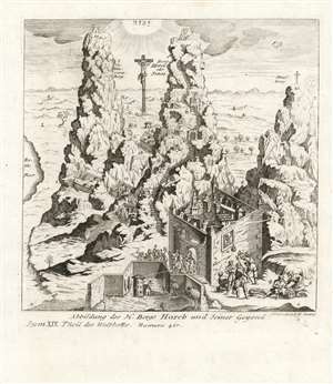
Abbildung Des H. Bergs Horeb und Seiner Gegend.
$450.00
Acquire
- Digital Map Information
- Suitable for large format printing
- Full resolution TIFF file
- ICC color profile embedded
- Delivered instantly via download link
This is a rare 1732 Joseph Stocklein depiction of Mount Horeb, (identifying it as Mount Sinai) Mount Saint Catherine, and a third mountain labeled 'Strasberg'. The stylized mountains are set in a dramatically foreshortened bird's eye view of the Holy Land, encompassing not only all of the Sinai Peninsula but also including the land of Canaan and (judging by the prominent Crucifixion) Jerusalem itself. Thus Stocklein's view places the site of Moses' receipt of the Ten Commandments in a markedly Christian framework. The view combines scenes from different stages in Biblical history: Atop Horeb/Sinai, a vignette numbered '7' shows Moses receiving the Commandments (the Ark of the Covenant lies beside him, awaiting the tablets.) Nestled between the mountains are the walled compounds of the Monastery of St. Catharina, built between 548 and 565 CE.
At the far left is a body of water, labeled as the Red Sea. At the top center, not to be mistaken for the sun (which can be seen rising to the right of the view, indicating east) is the radiance-streaming Tetragrammaton, reinforcing the identity of Mount Horeb as the 'Mountain of YHWH.' The view is numbered and lettered, with reference to an absent descriptive text. (more details)
At the far left is a body of water, labeled as the Red Sea. At the top center, not to be mistaken for the sun (which can be seen rising to the right of the view, indicating east) is the radiance-streaming Tetragrammaton, reinforcing the identity of Mount Horeb as the 'Mountain of YHWH.' The view is numbered and lettered, with reference to an absent descriptive text. (more details)