
Donovan, Charles John

Charles John Donovan (fl. c. 1878 - 1908) was a British military draughtsman and cartographer. No information is available on his early life and training, but he joined the Ordnance Survey Department in September 1878. He then transferred to the Intelligence Division of the War Office in April 1890 and was appointed to the Permanent Staff in August 1908. The known maps ascribed to him cover different parts of Nigeria.
Settling the Borders of British Nigeria.
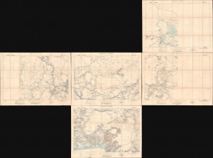
Lake Chad / Nikki / Central Nigeria. / Yola / Cross River.
$1,500.00
Acquire
- Digital Map Information
- Suitable for large format printing
- Full resolution TIFF file
- ICC color profile embedded
- Delivered instantly via download link
A concurrent set of five folding sheets, together forming a map covering central and eastern Nigeria, produced by the Intelligence Division of the British War Office in 1902 (with one map being dated 1905). The maps cover this region as it was roiled by opposition to British encroachments and was being negotiated over between the British and Germans, who controlled the neighboring colony of Kamerun. (more details)