
Dumas-Vorzet, Ernest

Ernest Dumas-Vorzet (18?? - 18??) was a French line and letter engraver active in Paris in the late 19th century. He engraved the lettering on nautical charts for the Dépôt des Cartes et Plans de la Marine. His later work is often associated with Émile Delaune (18?? - 19??) and Hachette et Cie. He is likely the father of Edouard Dumas-Vorzet, a French publisher and cartographer.
Contesting the Frontier during the U.S. Civil War.
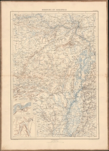
Missouri et Arkansas.
$375.00
Acquire
- Digital Map Information
- Suitable for large format printing
- File Size: 21.25 MB
- File Type: ZIP / TIFF
- ICC color profile embedded
- Delivered instantly via download link
This map of Missouri and Arkansas during the U.S. Civil War was prepared by Ernest Dumas-Vorzet for the scarce 1890 atlas volume of Philippe d'Orléans' Histoire de la Guerre Civile en Amérique. (more details)
Where the Civil War Started.
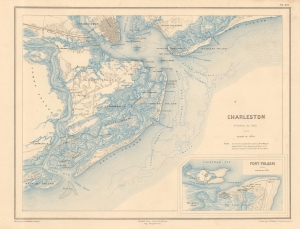
Charleston (Caroline due Sud).
$400.00
Acquire
- Digital Map Information
- Suitable for large format printing
- File Size: 8.82 MB
- File Type: ZIP / TIFF
- ICC color profile embedded
- Delivered instantly via download link
This is an 1890 Dumas Vorzet map of the city and harbor of Charleston, South Carolina, issued to illustrate the scarce atlas volume of the French edition of the French prince and Civil War veteran Philippe d'Orléans' Histoire de la Guerre Civile en Amérique. (more details)
Winning the Western Theater.
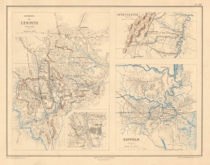
Environs de Corinth (Mississippi) / Winchester (Virginie) / Suffolk (Virginie).
$375.00
Acquire
- Digital Map Information
- Suitable for large format printing
- File Size: 7.32 MB
- File Type: ZIP / TIFF
- ICC color profile embedded
- Delivered instantly via download link
This sheet includes three intricate 1890 Dumas Vorzet maps of Corinth, Mississippi, and Winchester and Suffolk, Virginia, sites of battles during the American Civil War (1861 - 1865). It was issued to illustrate the scarce atlas volume of the French edition of the exiled french prince Philippe d'Orléans' Histoire de la Guerre Civile en Amérique. (more details)
One of the First Union Victories of the Civil War.
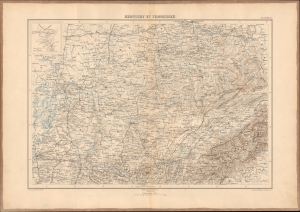
Kentucky et Tennessee.
$350.00
Acquire
- Digital Map Information
- Suitable for large format printing
- File Size: 23.03 MB
- File Type: ZIP / TIFF
- ICC color profile embedded
- Delivered instantly via download link
This impressive 1890 map of Kentucky, Tennessee, and portions of neighboring states was prepared by Ernest Dumas-Vorzet for his Histoire de la Guerre Civile en Amérique. Among the larger maps in the atlas volume of the work, it highlights a large portion of the Western Theater, a bright spot for the Union early in the war. (more details)
Turning the Tide in the West.
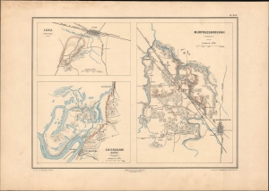
Murfreesborough (Tennessee). / Iuka (Mississippi). / Chickasaw Bayou (Mississippi).
$350.00
Acquire
- Digital Map Information
- Suitable for large format printing
- File Size: 9.65 MB
- File Type: ZIP / TIFF
- ICC color profile embedded
- Delivered instantly via download link
This is Ernest Dumas-Vorzet's 1890 map of Murfreesboro, Tennessee, and Iuka and Chickasaw Bayou in Mississippi, prepared for the 1890 book Histoire de la Guerre Civile en Amérique. (more details)
A Crushing Defeat for the Confederacy at Nashville.
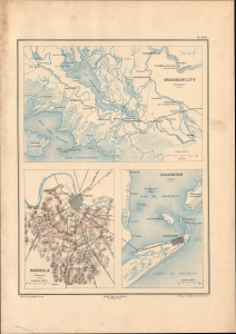
Brashear City (Louisianie) / Nashville (Tennessee) / Galveston (Texas).
$350.00
Acquire
- Digital Map Information
- Suitable for large format printing
- File Size: 10.28 MB
- File Type: ZIP / TIFF
- ICC color profile embedded
- Delivered instantly via download link
This sheet, including three detailed maps, was prepared by Ernest Dumas-Vorzet for the 1890 work Histoire de la Guerre Civile en Amérique. It maps battles at Nashville, Galveston, and Brashear City, three important battles in the Western and Trans-Mississippi Theaters of the U.S. Civil War. (more details)
Defending the Confederate Capital.
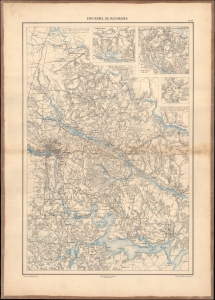
Environs de Richmond.
$350.00
Acquire
- Digital Map Information
- Suitable for large format printing
- File Size: 23.48 MB
- File Type: ZIP / TIFF
- ICC color profile embedded
- Delivered instantly via download link
This highly-detailed Dumas Vorzet map depicting Richmond and environs in eastern Virginia was issued to illustrate the scarce 1890 atlas volume of the French edition of Philippe d'Orléans' Histoire de la Guerre Civile en Amérique. This region was the site of multiple important battles, including the Peninsular Campaign of 1862 and the Overland Campaign of 1864. (more details)
The Western Theater - a Bright Spot for the Union.
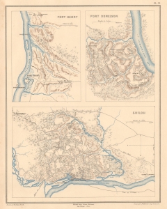
Fort Henry Fort Donelson Shiloh.
$350.00
Acquire
- Digital Map Information
- Suitable for large format printing
- File Size: 6.43 MB
- File Type: ZIP / TIFF
- ICC color profile embedded
- Delivered instantly via download link
This sheet includes three highly detailed 1890 Dumas Vorzet maps of Fort Henry, Fort Donelson, and Shiloh, Tennessee, sites of early battles in the Western Theater of the American Civil War. It was issued to illustrate the scarce atlas volume of the French edition of Philippe d'Orléans' Histoire de la Guerre Civile en Amérique. (more details)
Early Battles Point towards the Future Course of the Civil War.
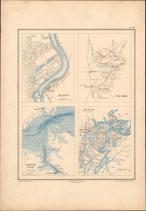
Belmont. / Pea Ridge. / Hampton Roads. / Ile No. 10 et ses abords.
$350.00
Acquire
- Digital Map Information
- Suitable for large format printing
- File Size: 9.1 MB
- File Type: ZIP / TIFF
- ICC color profile embedded
- Delivered instantly via download link
This is Ernest Dumas-Vorzet's 1890 map of the battles of Belmont, Pea Ridge, and Island No. 10, and the naval battle of Hampton Roads, prepared for his Histoire de la Guerre Civile en Amérique. (more details)
Early Maneuvers of the Civil War.
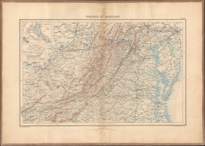
Virginie et Maryland.
$350.00
Acquire
- Digital Map Information
- Suitable for large format printing
- File Size: 24.6 MB
- File Type: ZIP / TIFF
- ICC color profile embedded
- Delivered instantly via download link
This highly detailed topographic map of Virginia and Maryland was prepared by Ernest Dumas-Vorzet. It appeared in the scarce 1890 atlas volume of the French edition of Philippe d'Orléans' Histoire de la Guerre Civile en Amérique. (more details)
The 'Other' Siege of Yorktown.
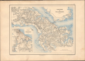
Yorktown et Williamsburg (Virginie) / Environs de Yorktown.
$375.00
Acquire
- Digital Map Information
- Suitable for large format printing
- File Size: 12.76 MB
- File Type: ZIP / TIFF
- ICC color profile embedded
- Delivered instantly via download link
An impressive map of Yorktown, Williamsburg, and environs in eastern Virginia, prepared by Ernest Dumas-Vorzet for the 1890 book Histoire de la Guerre Civile en Amérique. It depicts the terrain on which eponymous battles took place during the U.S. Civil War in 1862, part of the Peninsula Campaign, a failed Union march on Richmond. (more details)