This item has been sold, but you can get on the Waitlist to be notified if another example becomes available, or purchase a digital scan.
1880 Brault Map of Pacific Ocean Winds in July, August, and September
VentPacifiqueJuilSept-brault-1880$600.00

Title
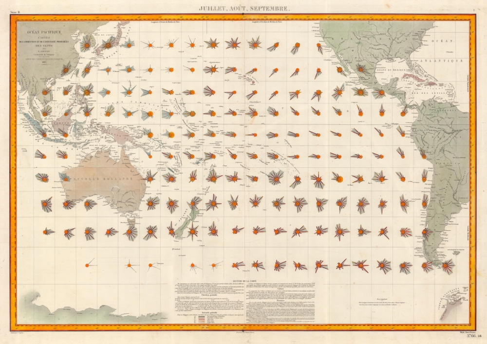
Océan Pacific - Cartes de la Direction et de l'Intensité Probables des Vents. Juillet Août Septembre.
1880 (dated) 26.5 x 37.25 in (67.31 x 94.615 cm) 1 : 26000000
1880 (dated) 26.5 x 37.25 in (67.31 x 94.615 cm) 1 : 26000000
Description
This is an 1880 Léon Brault significant map of Pacific Ocean winds. The map is innovative in its expression of both quantitative and qualitative data in relation to wind direction, intensity, and frequency - presaging the work of Matthew Fontaine Maury (1806 - 1873) in the mid-19th century.
A Closer Look
Brault's innovative wind roses fill the Pacific and Indian Oceans. The frequency of calm winds is noted at the center of the wind roses. The overall length of the segments represents the total number of winds blowing in that direction, with notations representing the frequency of each of the five different wind classifications. (At the time, the French used a scale of 10 wind classifications based on intensity. On his wind roses, Brault differentiates between Class 2, 3, 4, and 5 winds, and then grouped Classes 6-10, as these occurred rarely.) On each, the branches follow wind direction.Publication History and Census
This map was compiled and designed by Léon Brault, drawn by Ernest Dumas-Vorzet, engraved by C. Legros, and published by the Dépôt des Cartes et Plans de la Marine in 1880. We note two complete sets of Brault's four Pacific Ocean wind maps cataloged in OCLC which are part of the collections at the University of Oxford and the National Library of Australia. The separate map is not cataloged in OCLC and we have found no records of this map entering the private market.CartographerS
Louis Désiré Léon Brault (January 7, 1839 - August 27, 1885) was a French naval officer, meteorologist, and cartographer. Born in Vendôme, he attended the École Polytechnique beginning in 1859. He joined the French Navy in 1861, eventually rising to the rank of capitaine de frégate. He fell ill from dysentery in 1868, and during his convalescence began contemplating how wind is represented on maps. With this new fascination in mind, he requested a transfer to the Dépôt des cartes et plans de la Marine, which was granted. He began working at the Dépôt on March 17, 1869, but, after the French declaration of war beginning the Franco-Prussian War, Brault requested to be sent back to sea. He was assigned to the Invincible, an ironclad frigate. A recurrence of dysentery forced him to convalesce for the entirety of 1871. After regaining his health in January 1872, Brault asked to be reassigned to the Dépôt des cartes to finish his work on the wind maps. In 1874 Brault published the first set of wind map, a set of our maps of seasonal winds of the North Atlantic. He was named the Director of Meteorology at the Dépôt des cartes in 1878, a post he held until his death. Brault also published several books, including Traité d'astronomie et de la météorologie appliquées à la navigation. Brault eventually created wind maps for the Pacific, North Atlantic, South Atlantic, and Indian Oceans. More by this mapmaker...
Ernest Dumas-Vorzet (18?? - 18??) was a French line and letter engraver active in Paris in the late 19th century. He engraved the lettering on nautical charts for the Dépôt des Cartes et Plans de la Marine. His later work is often associated with Émile Delaune (18?? - 19??) and Hachette et Cie. He is likely the father of Edouard Dumas-Vorzet, a French publisher and cartographer. Learn More...
Dépôt des Cartes et Plans de la Marine (fl. 1720 - present), often called the Dépôt de Marine, was a French hydrographic mapping organization founded in 1720 under Charles-Hercule of Albert de Luynes (1674 - 1734). Much like the U.S. Coast Survey, the British Admiralty, and the Spanish Deposito Hydrografico, the Dépôt was initiated as a storehouse and distribution center of existing nautical and marine charts. Eventually the Dépôt initiated its own mapping activities in an attempt to improve and expand upon existing material. Some of the more prominent cartographers and hydrographers associated with the of Dépôt des Cartes were, Philippe Buache, Jacques-Nicholas Bellin, Giovanni Rizzi-Zannoni, Rigobert Bonne, and Jean Nicolas Buache. Learn More...
Condition
Good. Light wear and toning along original fold lines. Verso repair to a fold separation. Closed margin tears professionally repaired on verso.
References
OCLC 308344493, 1043373040.