
Fujita Ryou (藤田良)

Fujita Ryou (藤田良; fl. 1850 - 1959), also known as 'Kousai' was a Japanese cartographer of the late Edo Period. He produced a large map of Hokkaido in 1854. He is otherwise elusive.
AKA: 藤田良
Defending the borders in the wake of Commodore Perry.
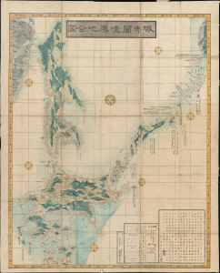
蝦夷闔境輿地全圖 / [Complete Map of All Lands within the Borders of Ezo].
$2,750.00
Acquire
- Digital Map Information
- Suitable for large format printing
- Full resolution TIFF file
- ICC color profile embedded
- Delivered instantly via download link
This is an important 1854 (Kaei 7) Japanese Edo period Fujita Ryou chromoxylographic map illustrating Hokkaido, Sakhalin, and the Kuril Islands. It was issued following the 1853 arrival of Commodore Matthew Perry, anticipating the opening of Hakodate as one of the five Japanese treaty ports. (more details)