
Huot, Victor

Victor Huot (August 26, 1867 - April 28, 1915) was a French cartographer. Little is known of his youth. He was employed by the publisher Hachette et Cie., contributing to its map publications such as the Atlas Universel de Geographie by Vivien Martin and Schrader. He produced maps for La Geographie, published by the Paris Geographical Society, of which he was a member. He produced a set of maps of the river basins of the French Alps for the Service des Grandes Forces Hydrauliques, and wrote the South America section for Onesime Reclus' Grande géographie Bong. He produced the monumental map of the Andes, surveyed by the 1903 French Scientific Mission. He developed an international reputation, becoming a member of the American Geographical Society. In 1915, Huot was a member of the French Army, likely the territorial reserves, which were fighting on the Western Front. At the time, Huot was above the age of service. (Even the oldest French conscripts, the territorials, were drawn from men below 45 years of age.) Huot was killed in battle on April 27 or 28, 1915, at the age of 48. This was probably in the Second Battle of Ypres. Although territorials were not intended for front line deployment, losses in the beginning of the war were so sharp that at Ypres these old reserves were in the front line when Germany made their first gas attacks, beginning on April 22.
First Scientific Mapping of the Andes.
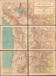
Régions des Hauts-Plateaux de l'Amérique du Sud (Bolivie, Argentine, Chili, Pérou) parcourues par la mission française. Carte dressée par V. Huot, d'après les travaux des membres de la mission, les sources originales inédites et les documents les plus récents.
$2,200.00
Acquire
- Digital Map Information
- Suitable for large format printing
- Full resolution TIFF file
- ICC color profile embedded
- Delivered instantly via download link
This is a scarce, monumental map of the South American highlands of Bolivia, Argentina, Chile, and Peru. The map was executed by the cartographer Victor Huot in 1905 based on extensive surveys performed by the 1903 - 1904 French Scientific Mission of Georges de Créqui-Montfort and anthropologist Eugene Sénéchal de la Grange. The Mission was multidisciplinary: in addition to its cartographic contributions, its members made forays into anthropology, linguistics, paleontology, and studies of the flora and fauna of the South American highlands. The survey was immediately hailed for the advances it represented in many fields. The map, in particular, was recognized as a foundational work: the Mission's surveys being the first scientific, firsthand mapping of the Andes. (more details)