
Hyatt, Cornelius

Cornelius Hyatt (October 10, 1831 - January 2, 1904) was a surveyor active on Long Island around the village of Newtown (Elmhurst), who produced several early plat maps of what would become Astoria, Elmhurst, Woodside, and other nearby neighborhoods as they were developing rapidly at the end of the 19th century. Few details of his life are known, but he appears to have been a longtime resident of the area, present since at least 1850, and was a farmer before - or in addition to - becoming a surveyor and civil engineer. Hyatt appears to have been a considerable landholder himself, including a homestead in the village of Winfield, now Woodside.
Origins of Astoria.
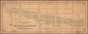
Map of Property Situate in the Fifth Ward, of Long Island City.
$1,800.00
Acquire
- Digital Map Information
- Suitable for large format printing
- File Size: 54.79 MB
- File Type: ZIP / TIFF
- ICC color profile embedded
- Delivered instantly via download link
A remarkable find, this one-of-a-kind 1891 plat map displays a portion of Astoria, Queens, New York City, around the intersection of Ditmars Boulevard and Steinway Street. It was prepared by surveyor Cornelius Hyatt and presents lands for sale owned by F. D. Kouwenhoven, a prominent landowner descended from New York's early Dutch settlers. (more details)