
Lamb, Francis

Francis Lamb (fl. 1667 - 1701) was an English engraver and mapmaker active in London during the second half of the 17th century. Working as an engraver Lamb produced a number of highly influential maps including four plates of the New World for inclusion in the 1676 Basset and Chiswell edition of Speed's "Prospect of the most famous parts of the world". He worked in conjunction many of the most prominent English map publishers of the 17th century including Richard Blome, John Seller, John Ogilby, Robert Morden, William Berry, Moses Pitt, Philip Lea, among others. Little is known of Lamb's personal life however he seems to have been a pupil of the British polymath Robert Hooke, who mentions him regularly in his journals. The dates of Lamb's birth and death are unknown, there is some speculation that he may have died around 1717. Baynton-Williams quotes abundantly with respect to Lamb from Hooke's diary, and the picture is of an exceedingly busy man with connections to many of the best geographical minds of his day. The novel maps he supplied for the 1676 edition of the Speed atlas may well have benefited even more from these connections than from his skill as an engraver.
Essential Map for the Carolina Collector.
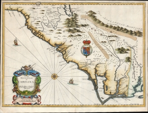
A New Description of Carolina.
$4,500.00
Acquire
- Digital Map Information
- Suitable for large format printing
- Full resolution TIFF file
- ICC color profile embedded
- Delivered instantly via download link
A bright example of the important and scarce map of the Carolina colony engraved by Francis Lamb for inclusion in the 1676 Bassett and Chiswell edition of John Speed's atlas. It is one of the earliest English maps of the colony acquirable by the collector, published just six years after the founding of Charleston. It is a map of seminal importance: an essential document in the history of the Carolinas and the British settlements in North America. (more details)