This item has been sold, but you can get on the Waitlist to be notified if another example becomes available, or purchase a digital scan.
1676 John Speed Map of Russia
Russia-speed-1676$1,250.00

Title
A Map of Russia.
1676 (undated) 15.25 x 20 in (38.735 x 50.8 cm) 1 : 9100000
1676 (undated) 15.25 x 20 in (38.735 x 50.8 cm) 1 : 9100000
Description
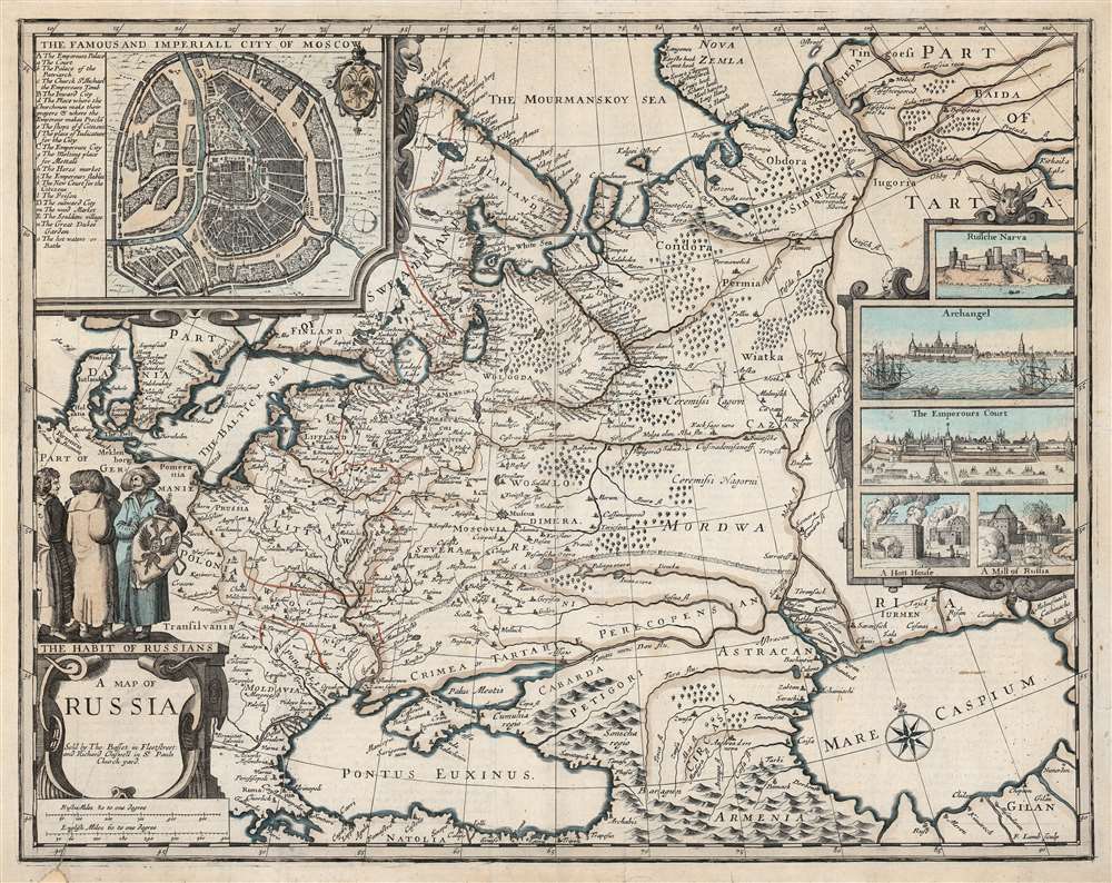
This is John Speed's scarce 1676 map of Russia, one of the first English maps of Russia and certainly the most decorative. The map is scarce, having appeared only in the latter, Basset and Chiswell edition of the Speed atlas. Centered on Moscow, the map covers from the North Sea to the Caspian Sea and from Nova Zembla to Trabzon (Black Sea south coast). There is a large and impressive inset map of Moscow: this is centered on the Kremlin, Belygorod, and the Kityagorod. Five inset views depict the Emperor's Court in the Kremlin, the vital port of Archangel, the Russian fort at Narva (in modern Estonia and a crucial stronghold on Russia’s western border), bathhouses and a mill. Above the cartouche are figures dressed in 'The Habit of Russians,' one of whom carries the Russian coat of arms.
Despite having ended in the early seventeenth century, the Time of Troubles has long been held as justification for Russia's support of strong, autocratic leadership. In 1613, Tsar Mikhail Romanov instituted a holiday named Day of Moscow’s Liberation from Polish Invaders - that is, Unity Day. This was celebrated throughout the Czarist era until 1917, when it was replaced with a commemoration of the Russian Revolution. Tellingly, Unity Day was reinstated in 2005 by president Vladimir Putin in 2005.
A Long Cartographic Lineage
This is one of a handful of maps engraved by Francis Lamb, and added to the atlas to make it more up to date and competitive with the Dutch atlases. Lamb assiduously copied Hessel Gerritsz's Tabula Russiae, which itself was attributed to Fyodor II Borisovich Godunov (1589 - 1605), a precocious young Tzar who ruled Russia from 1598 - 1605, when he was murdered by agents of False Dimitriy I. The well-educated young monarch produced manuscript maps of Russia and Moscow which survive in the Russian national archives. Godunov’s manuscript maps were brought to Amsterdam by Isaac Abrahamszoon Massa (1586 - 1643), a Dutch merchant and diplomat considered to have been the first western 'Kremlinologist.' Gerritsz obtained the Godunov maps from Massa, and compiled them into the original plates for his own map in 1613. After Gerritsz's death that plate came into the hands of Willem Janzoon Blaeu, whose family included it in Neuer Atlas. It is probably the Blaeu version which provided Lamb's model. The only earlier English map of Russia, printed by Richard Blome in 1669 and also engraved by Lamb, is a smaller and exceedingly Spartan copy of a map by Nicolas Sanson.A Tumultuous Russia
The map illustrates Russia as it appeared during the Time of Troubles (1598 - 1613), a period of political and social upheaval during the interregnum between the Czars of the Rurik Dynasty and the ascendency of the Romanovs. The period included the rise and fall of the 'False Dmitriys', pretenders claiming to be the heirs of the Rurik Dynasty. During this period Russia suffered from infighting, foreign invasion, and famine. It is estimated that nearly 1/3 of the population died.Despite having ended in the early seventeenth century, the Time of Troubles has long been held as justification for Russia's support of strong, autocratic leadership. In 1613, Tsar Mikhail Romanov instituted a holiday named Day of Moscow’s Liberation from Polish Invaders - that is, Unity Day. This was celebrated throughout the Czarist era until 1917, when it was replaced with a commemoration of the Russian Revolution. Tellingly, Unity Day was reinstated in 2005 by president Vladimir Putin in 2005.
Publication History and Census
This map was engraved by Francis Lamb for inclusion in the 1676 Basset and Chiswell The Theatre of the Empire of Great-Britain, which combined both of John Speed's atlases in a single volume. As a separate map, this is scarce in institutional collections with only four listings in OCLC. A dozen examples of the Theatre are listed.CartographerS
John Speed (1542 - 1629) was an important English historian and cartographer active in the early 17th century. Speed was born in Fardon, Cheshire and apprenticed under his father as a tailor. Though his heart was never in tailoring, Speed dedicated himself to this profession until he was about 50 years old. During all the time, Speed dedicated his spare time to research as amateur historian and mapmaker - even preparing several maps for Queen Elizabeth. In London, Speed's interest in history lead him to join the Society of Antiquaries. Eventually he befriended the wealthy Sir Fulke Greville, who sponsored his researches and eventually freed him from the haberdashery profession. Working with William Camden, Speed eventually published his 1611 Historie of Great Britaine. Though this history itself was amateurish and of minimal importance, Speed's inclusion of numerous maps of British Cities and town was seminal. In many cases these plans were the first maps ever issued of their respective subjects. Later, turning his attention more fully to Geography, Speed published the magnificent atlas Theatre of the Empire of Great Britaine and, just prior to his death, the 1627 A Prospect of the Most Famous Parts of the World. These were the first British world atlases and have a landmark position in the history of cartography. These atlases continued to be published well after Speed's death. More by this mapmaker...
Francis Lamb (fl. 1667 - 1701) was an English engraver and mapmaker active in London during the second half of the 17th century. Working as an engraver Lamb produced a number of highly influential maps including four plates of the New World for inclusion in the 1676 Basset and Chiswell edition of Speed's "Prospect of the most famous parts of the world". He worked in conjunction many of the most prominent English map publishers of the 17th century including Richard Blome, John Seller, John Ogilby, Robert Morden, William Berry, Moses Pitt, Philip Lea, among others. Little is known of Lamb's personal life however he seems to have been a pupil of the British polymath Robert Hooke, who mentions him regularly in his journals. The dates of Lamb's birth and death are unknown, there is some speculation that he may have died around 1717. Baynton-Williams quotes abundantly with respect to Lamb from Hooke's diary, and the picture is of an exceedingly busy man with connections to many of the best geographical minds of his day. The novel maps he supplied for the 1676 edition of the Speed atlas may well have benefited even more from these connections than from his skill as an engraver. Learn More...
Hessel Gerritsz (1581 – September 4, 1632) was a Dutch engraver, cartographer, and publisher active in Amsterdam during the late 16th and early 17th centuries, among the most preeminent Dutch geographers of the 17th century. He was born in Assum, a town in northern Holland in 1581. As a young man he relocated to Alkmaar to accept an apprenticeship with Willem Jansz Blaeu (1571-1638). He followed Blaeu to Amsterdam shortly afterwards. By 1610 he has his own press, but remained close to Blaeu, who published many of his maps. In October of 1617 he was appointed the first official cartographer of the Vereenigde Oost-Indische Compagnie (Dutch East Indian Company) or VOC. This strategic position offered him unprecedented access to the most advanced and far-reaching cartographic data of the Dutch Golden Age. Unlike many cartographers of his period, Gerritsz was more than a simple scholar and showed a true fascination with the world and eagerness to learn more of the world he was mapping in a practical manner. In 1628 he joined a voyage to the New World which resulted in the production of his seminal maps, published by Joannes de Laet in his 1630 Beschrijvinghe van West-Indien; these would be aggressively copied by both the Blaeu and Hondius houses, and long represented the standard followed in the mapping of the new world. Among his other prominent works are a world map of 1612, a 1613 map of Russia by the brilliant Russian prince Fyodor II Borisovich Godunov (1589 – 1605), a 1618 map of the pacific that includes the first mapping of Australia, and an influential 1630 map of Florida. Gerritsz died in 1632. His position with the VOC, along with many of his printing plates, were taken over by Willem Janszoon Blaeu. Learn More...
Isaac Abrahamszoon Massa (1586 - 1643) was a Dutch merchant, traveller and diplomat, and the envoy to Muscovy. His writings represent among the best primary sources Russia's Time of Troubles (Смутное время) and he produced some of the first maps of Eastern Europe and Siberia based on actual exploration. His cartographic contributions were quickly absorbed by the Dutch mapmaking trade, and can be seen in the works of Hessel Gerritz, Blaeu, Hondius and their descendants in the trade. Massa was born into a wealthy silk merchant's family, possibly Huguenot in origin. He first traveled to Russia in 1601 to further his family's trade interests there; during his time there he saw the latter half of Boris Godunov's reign and the outbreak of the Time of Troubles. He escaped a far more tumultuous Russia than the one to which he arrived in 1609. Massa's account of these events, which he presented to Stadtholder Maurice, were astonishingly not committed to print until the nineteenth century. He did, in 1612–1613, published two articles on Russian events and the geography of the Land of Samoyeds, accompanied by a map of Russia, which were published in a volume edited by Gerritsz. Massa's rendition of the Siberian coast, in particular, represented an advance in geography which was unsurpassed for decades, and consequently was widely copied. In 1614 Massa returned to Moscow as an official envoy of States-General of the Netherlands to obtain exclusive trade agreements and to investigate the trade routes into Persia. Following an abortive attempt to become an agent for Moscovia in 1624, he was able to find a place supporting the Swedish Gustaf II Adolf in pursuit of grain trade with Russia, for which efforts he was knighted by the Swedish King in 1625. Learn More...
Source
Speed, J. Theatre of the empire of Great-Britain.(T. Basset, T. / and R. Chiswel, R.: London) 1676.
Condition
Very good. One surface mend to lower left, visible in scales and cartouche. Else near excellent, with attractive old color.
References
Rumsey 12058.221. OCLC 937876565.