
Lea, Philip

Philip Lea (c. 1660 - 1700) was an English cartographer, globemaker, instrument maker, and publisher, active in London. Little is known of his early life, and what we do know is mainly to be found in his work. He apprenticed with Robert Morden in 1675. He produced his own maps as well as revising those of others (a long list, including not only Morden but also Moll, Ogilby, and Seller.) He collaborated directly with Morden, Ogilby, and Overton on an array of maps and globes. After his death in 1700 his wife, Ann Lea, took over the business and ran it for a quarter of a century.
Grandiose Statement of British Territorial Ambition. - First Map of America to name Philadelphia.
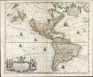
A New Mapp of America Devided According to the Best and latest Observations and Discoveries wherein are discribed by their Proper Names the seaverall Countries that Belonge to ye English which are wholly left out in all French and Dutch maps viz New Scotland, Long Iland, N. York, N. Jarsey, Mary Land, Pensilvania Carrolina etc. by Philip Lea at ye Atlas and Hercules in Cheapside and by J. Overton at the White Horse without Newgat London.
$9,500.00
Acquire
- Digital Map Information
- Suitable for large format printing
- Full resolution TIFF file
- ICC color profile embedded
- Delivered instantly via download link
This is a rare, important, separately issued 1688 English map of America, printed by Philip Lea and John Overton. It was first issued in 1684, explicitly as a rebuttal to French and Dutch maps and their representation of European spheres of influence in North America. It is the first general map of America to name Philadelphia, set in a boldly exaggerated depiction of 'The English Empire' in North America. (more details)