
Lloyd, J. T.

James T. Lloyd (fl. c. 1852 - 1865), publishing as J.T. Lloyd, was a New York City based map publisher active in the middle of the 19th century. J. T. Lloyd should not be confused with the competing New York map publisher, H. H. Lloyd, with whom he was often in conflict. Lloyd's maps, despite being printed in New York, frequently focused on the southern states, then in the midst of the American Civil War, likely because before the war Lloyd published steamboat directories of the Mississippi River. Lloyd's maps are noteworthy for their stupendous size and extensive detail as much as for their bombastic advertisements and self-promotion, with which he decorates both the rectos and versos. Surprisingly, given his propensity for self-aggrandizement, very little is known of Lloyd or his life.
'The Father of Waters again goes unvexed to the sea.'
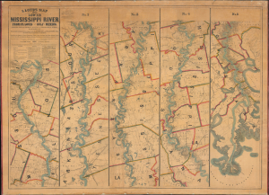
Lloyd’s Map of the Lower Mississippi River From St. Louis to the Gulf of Mexico. Compiled from Government Surveys in the Topographical Bureau...
$17,000.00
Acquire
- Digital Map Information
- Suitable for large format printing
- File Size: 104.66 MB
- File Type: ZIP / TIFF
- ICC color profile embedded
- Delivered instantly via download link
This is James T. Lloyd's engrossing 1863 large-format map of the Mississippi River, produced during the U.S. Civil War (1861 - 1865). It provides a comprehensive overview of the economically vital and strategically critical waterway, then a hotly contested theater of war vital to both the Union and the Confederacy. (more details)