
Loon, Johannes van

Johannes van Loon (c. 1611 - 1686), also known as Jan van Loon, was a Dutch mapmaker, mathematician, and engraver active in Amsterdam during the middle part of the 17th century. Van Loon issued the exceptional nautical atlas Klaer-Lichtende Noort-Ster ofte Zee Atlas in 1661. His is also known to have engraved several plates of Cellarius's Harmonia Macrocosmica Seu Atlas and to have contributed maps to nautical atlases and pilot books by Jacobsz, Jan Jansson, Johannes Janssonius van Waesbergen, and Robijin. Little is known of his personal life.
Most detailed atlas map of China and Korea to date.
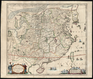
Imperii Sinarum Nova Descriptio.
$900.00
Acquire
- Digital Map Information
- Suitable for large format printing
- Full resolution TIFF file
- ICC color profile embedded
- Delivered instantly via download link
This is Jan Jansson and Jan van Loon's c. 1660 map of China and Korea: the earliest acquirable map to focus on China and Korea. It is among the most richly detailed early atlas maps of China, including the Great Wall, the legendary lake Chimay, and an early reference to Tibet. (more details)
Van Santen's matchless coloring heightened with lavish gold gilt.
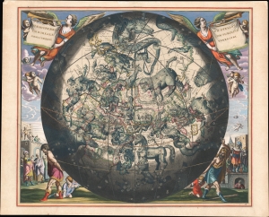
Haemisphaerium Stellatum Boreale cum Subiecto Haemisphaerio Terrestri.
$15,000.00
Acquire
- Digital Map Information
- Suitable for large format printing
- Full resolution TIFF file
- ICC color profile embedded
- Delivered instantly via download link
An exemplar regium of Andreas Cellarius's 1661 celestial map of the northern constellations with astounding Dirk Jansz Van Santen color. This chart stands out as an exemplary piece from a chart series long known for lavish presentation due both to fine engraving and the extraordinary colorwork of Van Santen. (more details)
Brahe's Model with Van Santen's matchless coloring heightened with lavish gold.
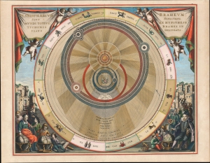
Planisphaerium Braheum Sive Structura Mundi Totius Ex Hypothesi Tychonis Braehi In Plano Delineata.
$15,000.00
Acquire
- Digital Map Information
- Suitable for large format printing
- Full resolution TIFF file
- ICC color profile embedded
- Delivered instantly via download link
An exemplar regium of Andreas Cellarius' 1661 celestial chart depicting the Solar system after the fascinating model of Tycho Brahe, embellished with astounding Dirk Jansz Van Santen color and gilt illumination. (more details)
Visualizing the Celestial Sphere.

Situs Terrae Circulis Coelestibus Circundatae.
$1,800.00
Acquire
- Digital Map Information
- Suitable for large format printing
- DPI: 600
- File Size: 62.91 MB
- File Type: ZIP / TIFF
- ICC color profile embedded
- Delivered instantly via download link
This beautiful work is Andreas Cellarius' celestial chart, in its 1708 Valk and Schenk edition, illustrating the position of the Earth within the celestial sphere divided into its circles. Its lush, baroque presentation - filled with clouds, putti, and muses - frames a useful visual glossary illustrating terminology important both to the astronomer and to the geographer. (more details)