This item has been sold, but you can get on the Waitlist to be notified if another example becomes available, or purchase a digital scan.
1678 / 1693 Hendrick Doncker Chart of the North Atlantic
CanadaArctic-doncker-1678$2,250.00

Title
Pascaart vande Noorder Zee custen van America vande West-hoeck van Ysland door de Straat Davits en Hudson, tot aen Terra Neuf.
1678 (undated) 20 x 23 in (50.8 x 58.42 cm) 1 : 8603000
1678 (undated) 20 x 23 in (50.8 x 58.42 cm) 1 : 8603000
Description
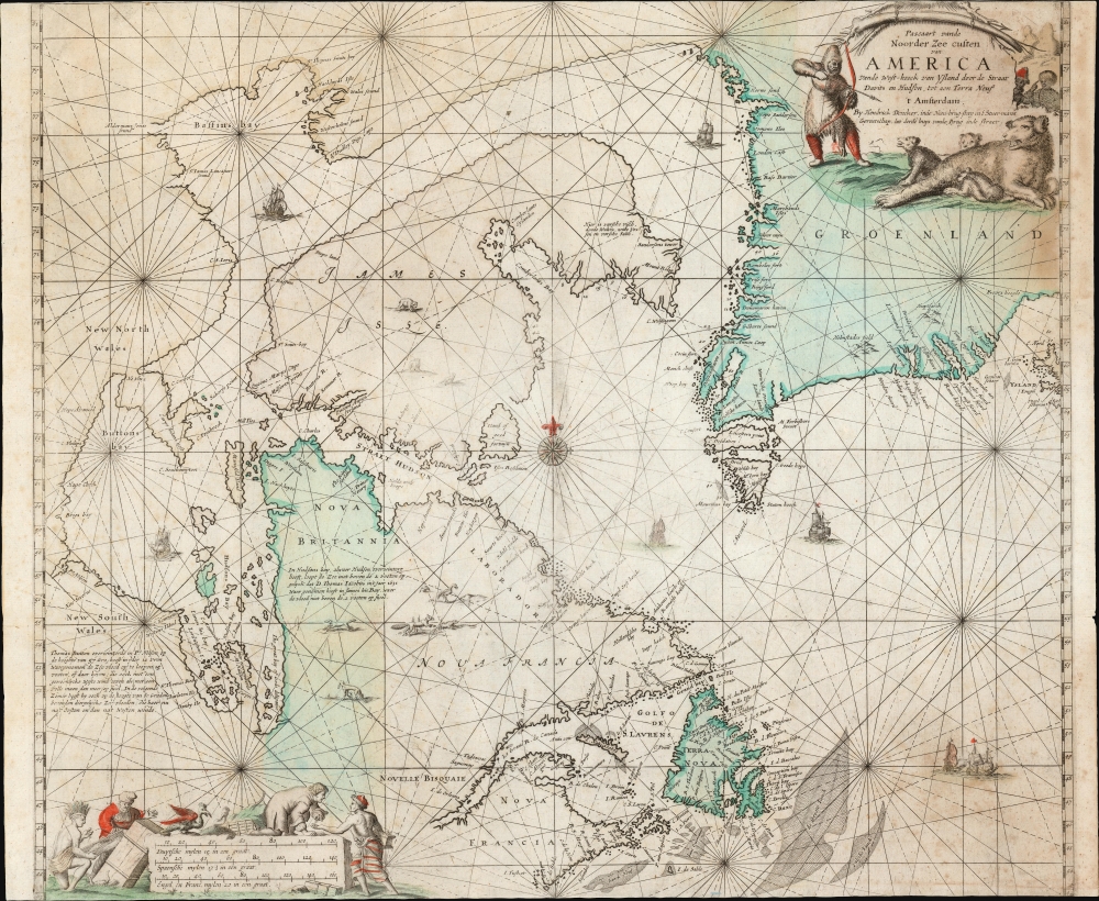
This is Hendrick Doncker's 1678 chart of the Canadian Arctic, Newfoundland, and Greenland. The map presents tantalizing potential routes points further west: the long-sought-after Northwest Passage. Though not the first in the lineage of Dutch nautical charts reaching back to van Loon's 1666 chart of these waters, this chart is among the rarest, seldom appearing in institutional collections and never in the modern map trade. According to Kershaw, this is among the first appearances of the Avalon Peninsula on the island of Newfoundland.
In the lower part of the chart is the mouth of the St. Lawrence River (Le Grand Riviere de Canada) and the Gulf of St. Lawrence. This includes the coasts of Labrador (Nova Francia) and all of Newfoundland (Terra Nova). As per Kershaw, Newfoundland is presented based on Mason's chart of 1625; as one of the first derivatives of Mason, this is among the first charts to present the characteristic shape of the Avalon Peninsula.
A Closer Look
The chart, with its rhumb lines, compass roses, sailing ships, and lively cartouches, is a classic of the Dutch nautical charts. Geographically, it spans from the coast of Nova Scotia in the south to the northern reaches of Baffin's Bay in the north; it charts the western limits of Hudson, Button, and Baffin bays, including tantalizing outlets to points further west, potential routes for the sought-after Northwest Passage. Resolution Island (Island of Good Fortune) appears near the center. The upper middle is dominated by Baffin Island, here termed James Isle. The Cumberland Sound is named. A note in Dutch indicates that here can be found 'various fresh fish, dead whales, white foxes, and fresh salmon'. To the top right is Greenland, whose bays and fjords remained poorly understood. The single bay, misidentified as a strait in the 16th century by Martin Frobisher, has here become two separate passages. The eastern limit of the chart only just reveals western Iceland.Plumbing the Northwest
Hudson and Baffin bays are both presented with possible outlets to the west; in Baffin Bay, Alderman Jonas Sound (Jones Sound) and St. James Lancaster Sound are prominent. Hudson Bay's 'Hope Check' and Brigs Bay suggest similar hopes. Extensive Dutch notes describe the wintering of Henry Hudson, Thomas Button, and Thomas James in their respective expeditions, reflecting the efforts over the prior century to reveal a Northwest Passage and probe the Arctic.In the lower part of the chart is the mouth of the St. Lawrence River (Le Grand Riviere de Canada) and the Gulf of St. Lawrence. This includes the coasts of Labrador (Nova Francia) and all of Newfoundland (Terra Nova). As per Kershaw, Newfoundland is presented based on Mason's chart of 1625; as one of the first derivatives of Mason, this is among the first charts to present the characteristic shape of the Avalon Peninsula.
Still the State of the Art
The charting of the northern parts of the world had been a major focus of explorers and mapmakers from the end of the 16th century through the 19th, and marked cartographic development is evident during the period leading up to Doncker's chart. The formulation of Baffin Island and Greenland first appeared in 1649 on Theunis Jacobsz' Pascaarte van Groenland, Yslandt, Hitlandt, Straet-Davids als mede Ian Mayen Eylandt; a series of charts similar to Jacobsz' with a centered Greenland followed. In 1666, Joannes van Loon presented his Pascaarte vande Noorder Zeekusten van America, which re-centered upon Baffin Island (then James Island) to include the coast of Labrador, Hudson Strait and Bay, Button Bay, and Baffin Bay. Doncker's 1670 Pascaarte vande Noorder Zeekusten van America van Groenland door de Straet Davis en Hudson tot aen Terre Neuf copies Van Loon closely. It remained in Doncker's atlas until replaced with the present work, which includes more of the eastern Greenland coast (including its glimpse of Iceland) and reaches further south, encompassing all of Newfoundland and the Grand Banks.Decorative Engraving
The chart is framed, at lower left and upper right, with beautifully engraved vignettes. The southwest engraving presents the chart's scales as though engraved on a stone, around which native and European figures haggle over the prices for various goods; money is seen changing hands. In the upper right, the chart's cartouche is framed with a hunting scene: a bearskin-clad archer draws a bead on a reclining bear and her cubs. In the background, two other hunters look on. One points to his fur hat, as if to say 'this hat comes from that animal,' thus communicating to the reader at home the object of Dutch interest in these distant lands.Publication History and Census
This chart was engraved for inclusion in Hendrick Doncker's sea atlases to replace the smaller 1670 Pascaarte vande Noorder Zeekusten van America van Groenland door de Straet Davis en Hudson...; both Kershaw and Burden cite a 1678 date for the present Pascaart. It is thought to have remained in various editions of Doncker's De Nieuwe Groote Vermeerdede Zee-Atlas ofte Water-Werelt as late as 1705. That said, we have seen examples of the 1678 Zee-Atlas still containing the earlier chart, and we have seen examples of the book from 1680 and 1684 that contained neither chart. The only examples of the atlas we have identified that actually contain this chart are dated 1693, and so contextually, we date it as such, corresponding to other Doncker charts that have come to us with consistent color, aging, and trimming. We are forced to conclude that this chart was not consistently included in the Zee-Atlas, contributing to its present rarity. We see only one example of the separate chart in OCLC, at the Biblioteca Nacional de España, although Burden lists ten institutional collections containing it. We have not seen this chart appear on the market, in dealers' catalogs, or in auction records.CartographerS
Hendrick Doncker (1626 - 1699) (a.k.a. Henri Donker) was a Dutch bookseller and publisher of sea charts and nautical atlases active in Amsterdam during the middle part of the 17th century. He maintained a presence on Nieuwe Brugsteeg, Amsterdam. He married Elizabeth Abrahamsd Rensing in 1647. Doncker was somewhat unique to this period in that he did not copy the work of earlier cartographers, instead producing his own map. Moreover, Doncker's charts were widely admired for their constant revision and overall accuracy. In addition to producing his own charts, he also collaborated with Pieter Goos and Anthonie Jacobsz to producing the pilot guide De Zeespiegel. Following his 1699 death, Doncker's remaining stock and valuable map plates were acquired by Johannes van Keulen. He was survived by a daughter, Anna Doncker. More by this mapmaker...
Johannes van Loon (c. 1611 - 1686), also known as Jan van Loon, was a Dutch mapmaker, mathematician, and engraver active in Amsterdam during the middle part of the 17th century. Van Loon issued the exceptional nautical atlas Klaer-Lichtende Noort-Ster ofte Zee Atlas in 1661. His is also known to have engraved several plates of Cellarius's Harmonia Macrocosmica Seu Atlas and to have contributed maps to nautical atlases and pilot books by Jacobsz, Jan Jansson, Johannes Janssonius van Waesbergen, and Robijin. Little is known of his personal life. Learn More...
Source
Doncker, H., Nieuwe Groote Vermeerderde Zee-Atlas ofte Water-Werelt, (Amsterdam: Doncker) 1693.
Condition
Very good. Trimmed to neatline on top and bottom with virtually no loss. Scuffing to bottom corners. Original hand color.
References
OCLC 733695036. Burden, P., The Mapping of North America, #498. Kershaw, K. A., Early Printed Maps of Canada, no. #202.