
Magyar Királyi Állami Térképészet

Magyar Királyi Állami Térképészet (1867 - 1952), translated 'Royal Hungarian State Cartography,' was a Hungarian government map publishing house active the early 20th centuries. The organization can trace its origins to the Austro–Hungarian Compromise of 1867, which gave Hungary marginal independence with the right to establish its own civil cartography - thus issuing tourist maps, school maps, cadastral plans, etc. More detailed topographical cartography remained under Austrian jurisdiction. This changed in 1918, during World War I, when Hungarian military leadership commissioned Colonel Lajos Hajts (1866 - 1933), professor of the Ludovika Military Academy, to lay the framework for a Hungarian State Cartography. This led to the formation on February 4, 1919, of the Hungarian Military Mapping Group (Magyar Katonai Térképező). This organization was based on the Austrian Militärgeographisches Institut model. The name changed in 1922 to Magyar Királyi Katonai Állami Térképészet (Royal Hungarian State Mapping Institute). In 1938, the name again changed, this time to the Magyar Királyi Honvéd Térképészeti Intézet (Royal Hungarian Institute of Military Cartography). The the Honvéd Térképészeti Intézet was folded into the Soviet-style Ministry of Defense in 1952.
The Big Five.
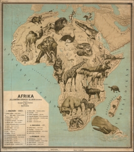
Afrika. Jellemzöbb Gerinces Állatai.
$1,500.00
Acquire
- Digital Map Information
- Suitable for large format printing
- File Size: 47.07 MB
- File Type: ZIP / TIFF
- ICC color profile embedded
- Delivered instantly via download link
This is Baloghné Hajós Terézia and Bálint János' striking 1928 Hungarian-language pictorial and zoological wall map of Africa. (more details)
Fauna of Asia, writ large.
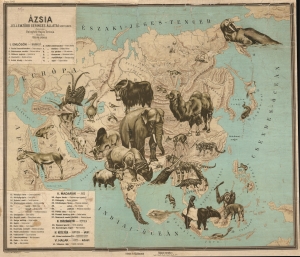
Ázsia. Jellemzöbb Gerinces Állatai.
$950.00
Acquire
- Digital Map Information
- Suitable for large format printing
- File Size: 57.69 MB
- File Type: ZIP / TIFF
- ICC color profile embedded
- Delivered instantly via download link
This Baloghné Hajós Terézia and Bálint János' 1928 Hungarian language pictorial zoological wall map of Asia. (more details)
Tourism in the midst of WWII.
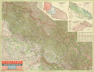
KÁRPÁTALJA. ПОДКАРПАТІЯ. KARPATENLAND. SUBCARPATHIE. SUBCARPAZIA.
$650.00
Acquire
- Digital Map Information
- Suitable for large format printing
- File Size: 84 MB
- File Type: ZIP / TIFF
- ICC color profile embedded
- Delivered instantly via download link
This is a 1940 Royal Hungarian Institute of Military Cartography map of Transcarpathia (Kárpátalja), today part of Ukraine known as Zakarpattia Oblast. The map was published less than a year after Hungary annexed the independent republic of Carpatho-Ukraine (discussed below). (more details)
Hungarian Transylvania.
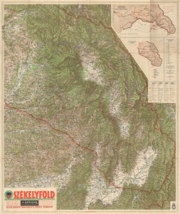
SZÉKELYFÖLD.
$500.00
Acquire
- Digital Map Information
- Suitable for large format printing
- File Size: 84.05 MB
- File Type: ZIP / TIFF
- ICC color profile embedded
- Delivered instantly via download link
This is a 1942 Royal Hungarian Institute of Military Cartography map of Székely Land (Székelyföld in Hungarian). This region was awarded to Hungary as part of the Second Vienna Award in August 1940 by Nazi Germany and Fascist Italy. (more details)
Romania's 'Hungarian Lands'.
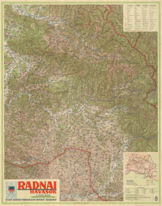
Radnai Havasok.
$275.00
Acquire
- Digital Map Information
- Suitable for large format printing
- File Size: 80.99 MB
- File Type: ZIP / TIFF
- ICC color profile embedded
- Delivered instantly via download link
This is a large-format 1942 map of the Rodna Mountains in the Eastern Carpathians produced by the Royal Hungarian Institute of Military Cartography. An example of wartime cartographic propaganda, the map both reflected and helped cement the control of this region by Hungary, to which it was granted in the Second Vienna Award of 1940, an 'agreement' brokered by Nazi Germany and Fascist Italy. (more details)