1942 Royal Hungarian Institute of Military Cartography Map of Székely Land, Transylvania
Szekelyfold-magyar-1942$500.00


Title
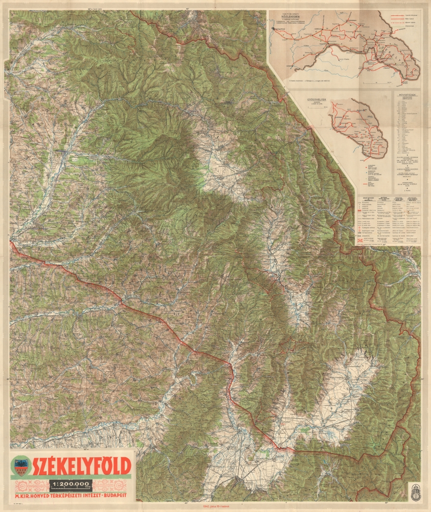
SZÉKELYFÖLD.
1942 (dated) 38.5 x 32.5 in (97.79 x 82.55 cm) 1 : 200000
1942 (dated) 38.5 x 32.5 in (97.79 x 82.55 cm) 1 : 200000
Description
This is a 1942 Royal Hungarian Institute of Military Cartography map of Székely Land (Székelyföld in Hungarian). This region was awarded to Hungary as part of the Second Vienna Award in August 1940 by Nazi Germany and Fascist Italy.
A Closer Look
Coverage embraces parts of present-day Transylva from just north of Brasov, which appears in the lower right, northwest to Bistrița (Beszterce), covering parts of Harghita, Covasna, and parts of Mureș counties, Romania. Cities and towns are labeled, with more important cities labeled prominently. Mountains are named with their elevations noted. Inset maps in the upper right illustrate regional roads, railroad networks, and medical centers.Székely Land
Székely Land (Székelyföld in Hungarian) is an ethnographic region located in the Eastern Carpathians, today incorporated into the eastern part of Transylvania, Romania. The region was historically the home of the Székelys, a Hungarian sub-ethnicity. Székely Land became part of the Habsburg monarchy at the end of the 17th century and remained part of the Austro-Hungarian Empire until after World War I (1914 - 1918). Székely Land (along with the rest of Transylvania and part of eastern Hungary) was made part of Romania in the terms of the 1920 Treaty of Trianon. The Second Vienna Award (a territorial dispute between Nazi Germany and Fascist Italy) returned (read: assigned) all of northern Transylvania, including Székely Land, to Hungary in August 1940. Soviet and Romanian forces occupied Transylvania in 1944, and the region was returned to Romania in 1947 as part of the Paris Peace Treaties.Publication History and Census
This map was created and published by the Royal Hungarian Institute of Military Cartography (Magyar Királyi Honvéd Térképészeti Intézet) in 1942. Rare.Cartographer
Magyar Királyi Állami Térképészet (1867 - 1952), translated 'Royal Hungarian State Cartography,' was a Hungarian government map publishing house active the early 20th centuries. The organization can trace its origins to the Austro–Hungarian Compromise of 1867, which gave Hungary marginal independence with the right to establish its own civil cartography - thus issuing tourist maps, school maps, cadastral plans, etc. More detailed topographical cartography remained under Austrian jurisdiction. This changed in 1918, during World War I, when Hungarian military leadership commissioned Colonel Lajos Hajts (1866 - 1933), professor of the Ludovika Military Academy, to lay the framework for a Hungarian State Cartography. This led to the formation on February 4, 1919, of the Hungarian Military Mapping Group (Magyar Katonai Térképező). This organization was based on the Austrian Militärgeographisches Institut model. The name changed in 1922 to Magyar Királyi Katonai Állami Térképészet (Royal Hungarian State Mapping Institute). In 1938, the name again changed, this time to the Magyar Királyi Honvéd Térképészeti Intézet (Royal Hungarian Institute of Military Cartography). The the Honvéd Térképészeti Intézet was folded into the Soviet-style Ministry of Defense in 1952. More by this mapmaker...
Condition
Very good. Light wear along original fold lines. Verso repairs to fold separations and at fold intersections. Slight loss at some fold intersections.
References
OCLC 809146854.