
Manning, F. E.

F. E. Manning (fl. c. 1940 - 1945) was an American journalistic cartography employed with the Chicago Sun. During World War II he produced numerous propagandistic maps for the Army Orientation Course of the Special Service Division Army Service Forces, a division of the United State War Department. Our research has, unfortunately, been able to unearth significant details regarding his personal life or his career at the Chicago Sun.
Created as an educational piece for American personnel serving overseas during World War II.
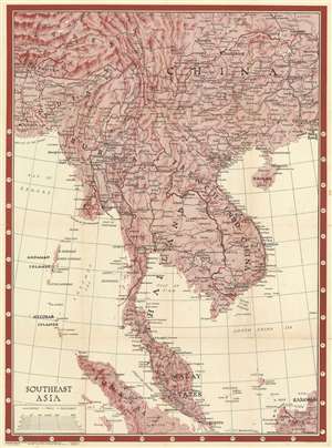
Southeast Asia. Newsmap. Monday, January 17, 1944. Week of January 6 to January 13. 227th Week of the War - 109th Week of U.S. Participation. Volume II No. 39F.
$400.00
Acquire
- Digital Map Information
- Suitable for large format printing
- Full resolution TIFF file
- ICC color profile embedded
- Delivered instantly via download link
This is a 1944 Morale Services Division Newsmap wall map of Southeast Asia. Created for American personnel serving overseas during World War II, the map depicts the region from Hankou, China to Borneo and Sumatra and from Calcutta to Hong Kong. This was a critical, if little-remembered theater of World War II, but little detail concerning the war appears, likely because that information would be severely out of date by the time the map finally reached its intended audience. The map was intended for general educational use concerning the area's geography, cities and towns are labeled throughout. Larger print identifies important cities, which were the ones that soldiers were more likely to recognize, including Singapore, Mandalay, Hong Kong, Macau, Canton (Guangzhou), and Kunming (the Chinese Nationalist capital), to name only a few. Roads that roughly correspond to the famous Burma Road are included as well, although are not labeled as such. (more details)