1944 Morale Services Division Newsmap Map of Southeast Asia
SoutheastAsiaVolll39F-newsmap-1944$400.00

Title
Southeast Asia. Newsmap. Monday, January 17, 1944. Week of January 6 to January 13. 227th Week of the War - 109th Week of U.S. Participation. Volume II No. 39F.
1944 (dated) 46.75 x 35 in (118.745 x 88.9 cm) 1 : 2500000
1944 (dated) 46.75 x 35 in (118.745 x 88.9 cm) 1 : 2500000
Description
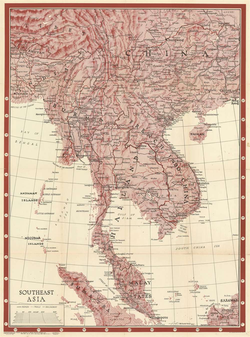
This is a 1944 Morale Services Division Newsmap wall map of Southeast Asia. Created for American personnel serving overseas during World War II, the map depicts the region from Hankou, China to Borneo and Sumatra and from Calcutta to Hong Kong. This was a critical, if little-remembered theater of World War II, but little detail concerning the war appears, likely because that information would be severely out of date by the time the map finally reached its intended audience. The map was intended for general educational use concerning the area's geography, cities and towns are labeled throughout. Larger print identifies important cities, which were the ones that soldiers were more likely to recognize, including Singapore, Mandalay, Hong Kong, Macau, Canton (Guangzhou), and Kunming (the Chinese Nationalist capital), to name only a few. Roads that roughly correspond to the famous Burma Road are included as well, although are not labeled as such.
The Verso Content
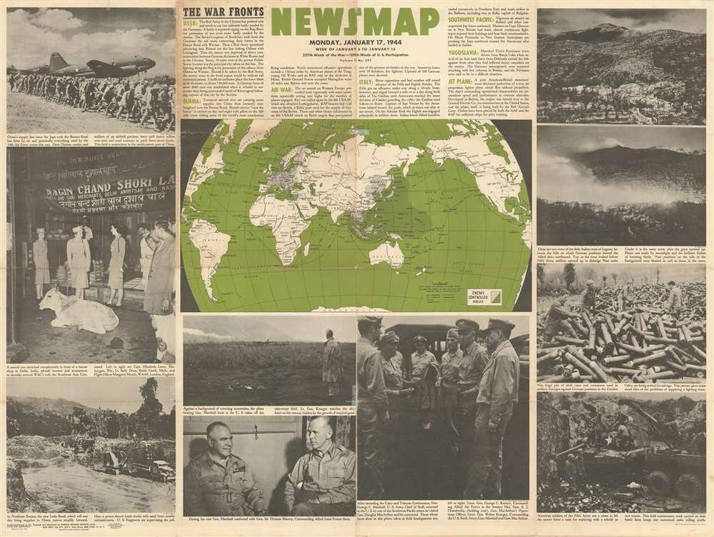
One of the attributes of the Newsmap genre is the abundance of content on one side and large graphic content of some kind (usually a map or propaganda poster) on the other. This edition is not an exception. Ten black and white photographs surround a world map highlighting territory still controlled by the Axis. Short paragraphs situated at top center provide summaries of the week's most important war-related events. In this case, these include fighting between the Nazis and the Soviet Red Army on the Eastern Front, significant raids in the air war over Europe; brutal fighting in southern Italy; and the completion of a jet engine by the Allies. The photographs present the viewer with images of a small Italian village before and after an Allied artillery barrage, three images of U.S. Army Chief of Staff General George Marshall's visit to the Southwestern Pacific to visit General Douglas MacArthur, and three WACs encountering a sacred cow in a Delhi, India bazaar.Publication History and Census
The map of Southeast Asia was drawn by F.E. Manning, and the whole was prepared and distributed by the Morale Services Division of the War Department. Ten examples are cataloged in OCLC and are part of the institutional collections at Pennsylvania State University, Denison University, Ohio Wesleyan University, Davidson College, the University of Michigan, the Library of Michigan, the University of Illinois at Urbana-Champaign, Southern Illinois University, the University of Missouri and the Denver Public Library.CartographerS
The Army Orientation Branch (1940 - c. 1949) created special maps for teaching the Army Orientation Course and was based at The Pentagon in Washington, D.C. The Army Orientation Branch was part of the Information and Education Division. More by this mapmaker...
F. E. Manning (fl. c. 1940 - 1945) was an American journalistic cartography employed with the Chicago Sun. During World War II he produced numerous propagandistic maps for the Army Orientation Course of the Special Service Division Army Service Forces, a division of the United State War Department. Our research has, unfortunately, been able to unearth significant details regarding his personal life or his career at the Chicago Sun. Learn More...
Source
NEWSMAP Series.
Newsmaps were published weekly between April 1942 and March 1946. Their content usually featured world maps, short summaries of the week’s military action, and photographs of troops and materiel. Early Newsmaps were printed on one side only, but, later in the war, they were printed on both sides, with the reverse bearing large-format maps, photographs, or other visual information. Several different versions of Newsmaps were produced: a large domestic version, a smaller overseas version, and an industrial version, which included more information about war production efforts. Two other editions appear in the United States Government Publications Monthly Catalogs, a 'Newsmap Special Edition' and a 'Newsmap Special Supplement for Special Training Units'.
Per the National Archives and Records Administration, ‘NEWSMAPS were not issued for general distribution. The posters were distributed to military installations, government and civilian groups working on War Department projects, and certain depository libraries, as designate by Congress, and one copy to Congressmen, if requested.’ The importance of the Newsmaps to the Army is related in the 1944 Basic Field Manual for The Special Service Company. The Manual states that as soon as the company reaches its destination ‘the company commander should contact the Special Service Branch in theater of operations headquarters, for copies of the weekly Newsmap.’ Also per the Manual
Per the National Archives and Records Administration, ‘NEWSMAPS were not issued for general distribution. The posters were distributed to military installations, government and civilian groups working on War Department projects, and certain depository libraries, as designate by Congress, and one copy to Congressmen, if requested.’ The importance of the Newsmaps to the Army is related in the 1944 Basic Field Manual for The Special Service Company. The Manual states that as soon as the company reaches its destination ‘the company commander should contact the Special Service Branch in theater of operations headquarters, for copies of the weekly Newsmap.’ Also per the Manual
The librarian should check the weekly Newsmap as soon as it is made available and should post it in a conspicuous place. He should take steps to see that the place where the Newsmap is posted is made known to all troops of the area in which the company or platoon is operating. This can be done effectively through notices in soldier newspapers, verbal announcements by those directly in charge of troops, and by posting announcements on bulletin boards.
Condition
Good. Exhibits slight wear and a few minor splits along old fold lines, particularly at fold intersections. Very minor loss at two fold intersections. Old folds stabilized where required with archival tissue on verso.
References
OCLC 416656295.