
McLaren, John Wilson

John Wilson McLaren (1896 - 1988), often as J. W. McLaren, was a Scottish-born Canadian painter, illustrator, and owner of a successful graphics art firm in the mid-20th century. Emigrating to Canada with his family as a child, McLaren gravitated towards the graphic, literary, and performing arts and served as an entertainer and comedian for Canadian units in the First World War. After the war, McLaren worked for the firm Rous and Mann in Toronto before founding his own graphic arts company and partnering with John McCaul, who operated the sales portion of the business. The company found quick success and signed up many leading Canadian companies as clients. McLaren's aesthetic was up-to-date and his methods even avant-garde; he was among the first to use plasticine to produce three-dimensional promotional sets. In 1950, McLaren and McCaul closed operations. McLaren briefly continued the business with his son, John, as McLaren and Son, Ltd., but this company lasted only two years and J. W. McLaren began a long retirement filled with painting and other artistic works.
Little-known WWII octopus map.
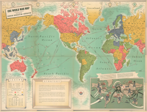
CBC World War Map on Mercator's Projection.
$750.00
Acquire
- Digital Map Information
- Suitable for large format printing
- Full resolution TIFF file
- ICC color profile embedded
- Delivered instantly via download link
This is a colorful, large-format c. 1942 Canadian Broadcasting Corporation (CBC) pictorial map of the world illustrating events early in World War II (1939 - 1945). Aside from presenting the conflict from the often-overlooked Canadian perspective, the map is notable for its distinctive aesthetic. Of note, a pictorial map in the lower right incorporates everyone's favorite map monster - the geo-octopus - popularized by Fred Rose in the late 1800s, to illustrate the grasping reach of Nazi German and Imperial Japanese expansion. (more details)