
Mohandesi, Mohammad-Reza

Mohammad-Reza Mohandesi (محمدرضا مهندسی, Mohammad-Reza Mohandes, Mohammad-Mirza Mohandes; fl. c. 1880 - 1883) was an Iranian engineer and surveyor active in the late 19th century. He is best known for drafting, with one Colonel Qarajadāghī, an 1880 plan of Tabriz using modern surveying methods. Both Mohammed Reza and Qarajadāghī were affiliated with the military college of Tabriz when preparing the map, with Reza teaching mathematics at his alma mater and seemingly employing students in the preparation of the map. Afterwards, he was tasked with preparing a map of Seistan (Sistan) Province in eastern Iran in 1883 that also aimed to demarcate the border with Afghanistan.
First printed map of Tabriz.
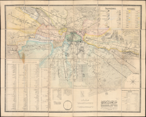
نقشه دارالسلطنه تبریز / [Map of Dār al-Salṭana (the Royal City) Tabriz].
$17,000.00
Acquire
- Digital Map Information
- Suitable for large format printing
- Full resolution TIFF file
- ICC color profile embedded
- Delivered instantly via download link
This rare 1880 Persian-language map of Tabriz, Iran, was prepared by engineer Mohammad Reza and military officer Colonel Qarajadāghī at the pioneering Tabriz Darulfunun (Tabriz State School). It is notable not only as one of the few surviving Persian-language maps from the 19th century and as the most detailed map of Tabriz at the time, but also for reflecting the situation of Tabriz and Qajar Iran. Located in the far northwest of Iran, Tabriz was on the front lines of a decades-long imperial tug-of-war between Qajar Iran, Tsarist Russia, and the Ottoman Empire. The city's proximity to Europe also supported a flourishing commercial economy and the early introduction of new technologies and practices, including recent developments in lithographic printing and scientific surveying. (more details)