
O'Toole, Larry

Larry O'Toole (1909 – April 10, 1951) was a Rockport, Massachusetts based adventurer, visual artist, and muralist. For a time, he was the official artist of the U.S. Coast Guard. He also painted several murals, known for their 'salty humor,' for American naval bases. At least one is in the Boston Navy Officer's Club. From 1938 – 1939, O'Toole, also an accomplished sailor, manned movie star Sterling Hayden's square-rigged brigantine, the 'Florence Robinson,' on a voyage to Tahiti. O'Toole made few maps, but his Salty Map of Cape Ann is a notably fine example of mid-20th century pictorial mapmaking.
Pictorial map of Cape Ann, Massachusetts.
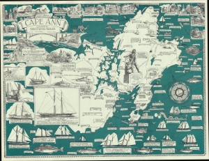
A Salty Map of Cape Ann.
$750.00
Acquire
- Digital Map Information
- Suitable for large format printing
- File Size: 760.07 MB
- File Type: ZIP / TIFF
- ICC color profile embedded
- Delivered instantly via download link
This is a 1947 Larry O'Toole pictorial map of Cape Ann, Massachusetts. Cape Ann is in northeastern Massachusetts, in Essex County, about 30 miles from Boston. A richly illustrated map, A Salty Map of Cape Ann is rich with historical and practical information. Most of the content is intended for summer residents and vacationers, making claims that 'the best sport fishing on the east coast' is off Cape Ann, or that there is good fishing for 'landlubbers' on Dog Bar Breakwater. Contemporary facts about the area are also given, such as '6 million pounds of lobster handled here in 1947'. (more details)