
Petruccelli, Antonio

Antonio Petruccelli (1907-1994) began his career as a textile designer. Petruccelli became a freelance illustrator in 1932 after winning several House Beautiful cover illustration contests. His work eventually appeared on the covers of Fortune, The New Yorker, Collier’s Today and House Beautiful magazines. ‘Tony was Mr. Versatility for Fortune. He could do anything, from charts and diagrams to maps, illustrations, covers, and caricatures,’ said Francis Brennan, the art director for Fortune. Over the course of his career, Petruccelli won several important design awards. Antonio Petruccelli died at age 87 on November 11, 1994.
An ominous look at Japan's expansionism during the 1930s.
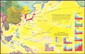
The Expanding Empire of Japan.
$175.00
Acquire
- Digital Map Information
- Suitable for large format printing
- File Size: 14.65 MB
- File Type: ZIP / TIFF
- ICC color profile embedded
- Delivered instantly via download link
This is a 1936 Antonio Petruccelli and Richard Edes Harrison map of the world highlighting the advance of the Japanese Empire in the Pacific. Depicting from Calcutta to San Francisco and from Alaska to Australia, Petruccelli and Harrison paint Japan and Korea (then occupied by the Japanese) deep red. Petruccelli and Harrison then use red to indicate areas of land and sea military advance, along with areas of increased economic activity and control. The Japanese established the puppet state of Manchukuo in 1932, after invading northeastern China. Within a year of this map's publication, Imperial Japan would launch the Second Sino-Japanese War, which would expand into the Pacific War with the United States after the surprise attack on Pearl Harbor on December 7, 1941.
Red arrows emphasize Japan's advance through Manchukuo into northern China, while designs that look like ship's wakes, spread in every direction from Japan and overtake Formosa, the Marianas Islands, Caroline, Islands, and Marshall Islands, among others. No country in the region is immune from an increase in Japanese economic influence, as is evident by the starburst patterns along their coastlines. Bar graphs in the lower right corner visually present this 'yen imperialism', as it is referred to here. Petruccelli and Harrison make Japan's economic and expansionist ambitions immediately apparent, and it likely created feelings of foreboding in its viewers when it was published. (more details)
Red arrows emphasize Japan's advance through Manchukuo into northern China, while designs that look like ship's wakes, spread in every direction from Japan and overtake Formosa, the Marianas Islands, Caroline, Islands, and Marshall Islands, among others. No country in the region is immune from an increase in Japanese economic influence, as is evident by the starburst patterns along their coastlines. Bar graphs in the lower right corner visually present this 'yen imperialism', as it is referred to here. Petruccelli and Harrison make Japan's economic and expansionist ambitions immediately apparent, and it likely created feelings of foreboding in its viewers when it was published. (more details)
The 'Great Circle' - verso covered in military aviation information.
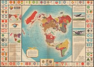
Global Map for Global War and Global Peace.
$400.00
Acquire
- Digital Map Information
- Suitable for large format printing
- Full resolution TIFF file
- ICC color profile embedded
- Delivered instantly via download link
This is a 1943 Antonio Petruccelli and Aluminum Company of America map of the world. The map features the novel Azimuthal Equidistant Projection, notable for illustrating accurate point-to-point distances. (more details)
American Airlines at the dawn of the Jet Age.
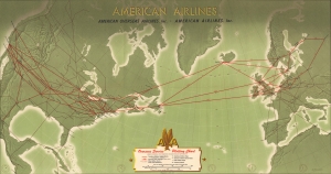
American Airlines Overseas Service Plotting Chart.
$225.00
Acquire
- Digital Map Information
- Suitable for large format printing
- Full resolution TIFF file
- ICC color profile embedded
- Delivered instantly via download link
This is a 1950 Antonio Petruccelli American Airlines route map of the United States and Europe. Published at the dawn of the Jet Age (although jet airliners would not be introduced to the U.S. until later in the decade), this map is part of the legacy of increased civilian airline travel in the years after World War II (1939 - 1945) and the advent of relatively easy global travel. (more details)