
Regional Plan of New York and Environs

Regional Plan of New York and Environs (1922 - present), or Regional Plan Association (abbreviated as RPA), is a nonprofit advisory organization founded by urban planners and civic leaders to develop comprehensive plans for infrastructure, transportation, zoning, and other aspects of urban planning in the New York City metropolitan area. Publishing its first regional plan in 1929, three subsequent plans followed in the 1960s, 1990s, and 2010s. Although the organization's focus has changed somewhat as the city has (adding, for example, a focus on preparing for climate change in recent years), it has consistently advocated for more affordable housing, greenspace, playgrounds, and mass transit, to improve the lives of residents of the city and its surrounding region. Despite not being a government body, the organization has had an influence on multiple projects in the New York City area, including the George Washington Bridge and the revitalization of both neighborhoods and greenspace in the city.
Infographic analysis of the New York Commute - in 1922!
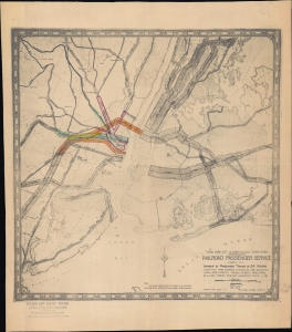
New York City and Contiguous Territory Railroad Passenger Service showing the Number of Passenger Trains in 24 Hours...
$1,200.00
Acquire
- Digital Map Information
- Suitable for large format printing
- File Size: 7.51 MB
- File Type: ZIP / TIFF
- ICC color profile embedded
- Delivered instantly via download link
This is a 1922 Regional Plan proof state infographic map of New York City, highlighting passenger rail traffic. The map is an early attempt to analyze the New York commute to better manage passenger rail networks. (more details)
Planning New York City's Highway System.
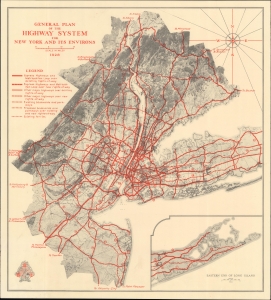
General Plan of the Highway System for New York and Its Environs.
$800.00
Acquire
- Digital Map Information
- Suitable for large format printing
- File Size: 26.34 MB
- File Type: ZIP / TIFF
- ICC color profile embedded
- Delivered instantly via download link
A highly detailed 1928 planning map of highways in the New York City metropolitan area produced by the nonprofit organization Regional Plan of New York and Environs. It presents the ambitious scheme, partially realized, for accommodating the growth of the city and the greater use of automobiles over trains as the primary means of urban and suburban transportation. (more details)