
Rotz, Jean (Johne Rotz)

Jean Rotz, or Johne Rotz ( c. 1505 - c. 1560) was a 16th-century French-Scottish ship's captain, navigator, and hydrographer. Very little is known about his life. Born to a Scottish father and a French mother, he is remembered for his work as a member of the Dieppe school of chartmaking. He is known to have traveled to Brazil in 1539; he may have accompanied the Parmentiers on their 1529 voyage to Sumatra. His was certainly the first chart of Sumatra based on firsthand knowledge, providing the basis for Ramusio's 1556 map of the island. The failure of Rotz's efforts to join the court of King Francois I led him to seek his fortune across the channel, where he would enter the service of Henry VIII. His atlas, the Boke of Idrography, survived as a gift to the King. Rotz would be employed by King Henry as a privateer - until Henry's death led him to shift allegiance again to France in 1547. His date of death is not known, but he was known to have been involved in Scottish affairs as late as 1560,
AKA: Johne Rotz
First separate map of any Southeast Asian island to be based on actual observation.' - Suarez
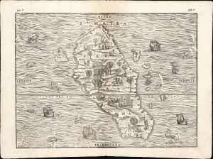
Sumatra / Taprobana.
$750.00
Acquire
- Digital Map Information
- Suitable for large format printing
- Full resolution TIFF file
- ICC color profile embedded
- Delivered instantly via download link
This is the 1606 issue of Giovanni Battista Ramusio's seminal map of Sumatra, 'the first separate map of any Southeast Asian island to be based on actual observation' (Suarez) and one of the first European maps to focus narrowly on so remote a part of the world. It is derived ultimately from the charts of Pierre Crignon, Dieppe navigator and chartmaker, who attended the 1529 attempt of Jean and Raoul Parmentier to set up a trading colony in Sumatra on behalf of the French. The Parmentiers failed and died overseas, but the account of their voyage survived, along with the first detailed charting of the island - preserved in print here. (more details)