
Sandby, Paul
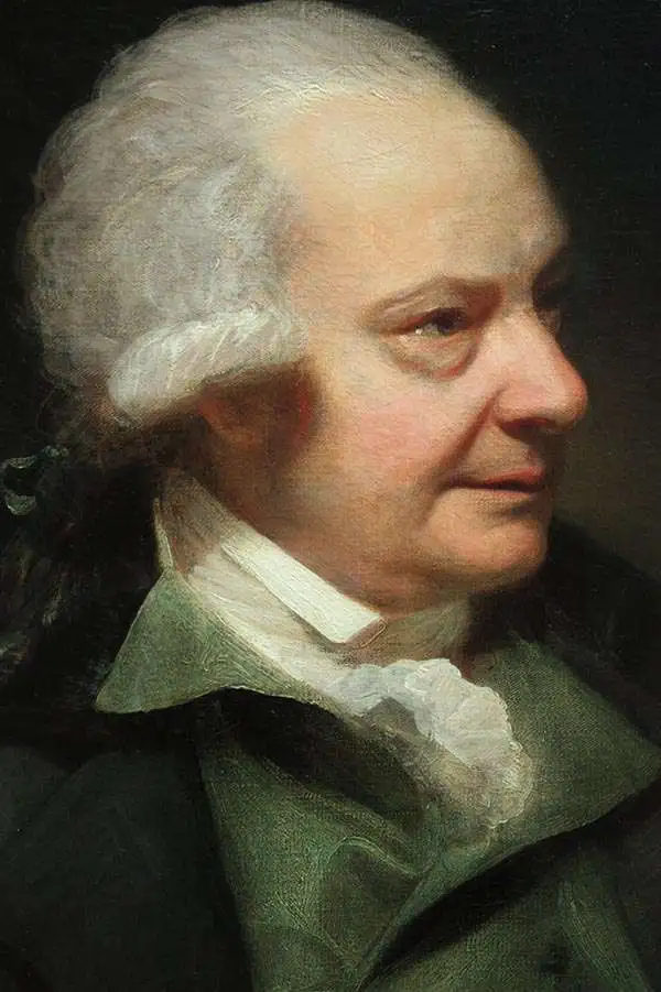
Paul Sandby (1731 - November 7, 1809) was an English architect, cartographer, engraver, and landscape artist active in the second half of hte 18th and early 19th centuries. Sandby was born in Nottingham. It is not clear where he learned to paint and draw, but in 1741, he relocated to London to join his older brother, Thomas Sandby (1721 - 1798), at the Board of Ordnance at the Tower of London. By 1743, he earned an appointment as a private secretary and draughtsman for William Augustus, Duke of Cumberland. He accompanied Cumberland on various military campaigns in the Scottish Highlands. Afterward, between 1747 and 1751, he worked as chief draftsman on the Military Survey of Scotland, conducted after the Jacobite Rising of 1745. He then retired to Windsor Great Park, where he was appointed Deputy Ranger (under Cumberland). Between his salary at the Board of Ordnance and as a deputy ranger, he was able to lead a leisurely, independent life dedicated to his art. He and his brother were among the 28 founding members of the Royal Academy. He died at his house in Paddington on November 7, 1809, and was buried in the burial ground of St George's, Hanover Square. In his obituaries, Sandby was described as the 'father of modern landscape paineting in watercolor.'
Victim of the French and Indian War.
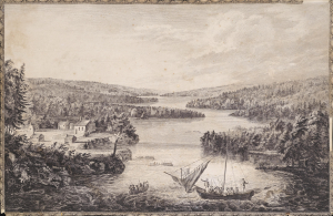
[A View of Miramichi, a French Settlement in the Gulf of St Laurence, destroyed by Brigadier Murray detached by General Wolfe for that purpose, from the Bay of Gaspe / Vue de Miramichi Établissement François dans le Golfe de St Laurent, détruit par le Brigadier Murray, détaché à cet e effet de la Baye de Gaspé, par le Général Wolfe].
$1,500.00
Acquire
- Digital Map Information
- Suitable for large format printing
- Full resolution TIFF file
- ICC color profile embedded
- Delivered instantly via download link
This is Hervey Smyth and Paul Sandby's portrayal of the settlement of Miramichi on the Miramichi River in New Brunswick that appeared in the 1760 Six Views of the Most Remarkable Places of the Gulf and River St. Laurence (later Scenographia Americana), published in London. The strategically located settlement was targeted by the British during the French and Indian War (Seven Years' War) and completely sacked. (more details)
'the origin of the log cabin as a symbol of the American experience.' - Gilbron
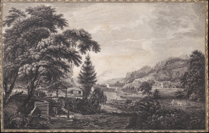
A Design to Represent the Beginning and Completion of an American Settlement or Farm.
$3,250.00
Acquire
- Digital Map Information
- Suitable for large format printing
- Full resolution TIFF file
- ICC color profile embedded
- Delivered instantly via download link
This is Thomas Pownall and Paul Sandby's illustration of the evolution of an American farmstead, from log cabin to gentlemanly estate. It is arguably the most famous and impactful image from the 1761 Six Remarkable Views in the Provinces of New York, New Jersey and Pennsylvania, published in London. This view is not only one of the earliest illustrations of American settler life, but it has also been credited by Gilbron as 'the origin of the log cabin as a symbol of the American experience.' (more details)
Religious Refuge on the American Frontier.
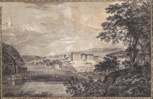
[A View of Bethlem, the great Moravian settlement in the province of Pennsylvania / Vue de Bethlem, principal etablissement des Freres Moraves dans la province de Pennsylvania].
$2,000.00
Acquire
- Digital Map Information
- Suitable for large format printing
- Full resolution TIFF file
- ICC color profile embedded
- Delivered instantly via download link
This is Thomas Pownall and Paul Sandby's depiction of the town of Bethlehem, Pennsylvania, that appeared in the 1761 Six Remarkable Views in the Provinces of New York, New Jersey and Pennsylvania (and later the Scenographia Americana), published in London. At the time, the town was among the most unusual and innovative in Britain's American colonies, being home to a strict and industrious Moravian community. (more details)
One of the Great Natural Wonders of the American Colonies.
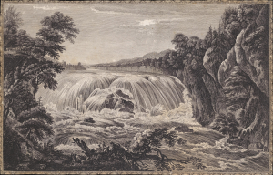
[A view of the great Cohoes Falls, on the Mohawk River, the fall about seventy feet, the river near a quarter mile broad / Vue de la grande cataracte de Cohoes, sur la riviere des Mohawks, la hateur est l'environ 70 pieds, 1 sa riviere a pres l'un quart de mile de large].
$1,500.00
Acquire
- Digital Map Information
- Suitable for large format printing
- Full resolution TIFF file
- ICC color profile embedded
- Delivered instantly via download link
This is Thomas Pownall and Paul Sandby's portrayal of the Cohoes Falls on the Mohawk River in New York that appeared in the 1761 Six Remarkable Views in the Provinces of New York, New Jersey and Pennsylvania (later Scenographia Americana), published in London. The falls were one of the great natural wonders of Britain's American colonies and, in the following decades, played an important role in the development of the Erie Canal and early industry in Upstate New York. (more details)
Natural Wonder, Engine of Industry.
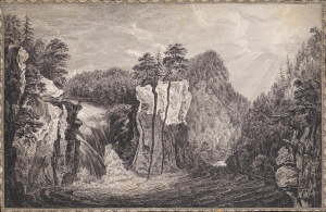
[A View of the Falls on the Passaick, or Second River in the Province of New Jersey / Vue de l'cataracte du Passaick, ou seconde riviere, dans la province du Nouveau Jersey].
$1,500.00
Acquire
- Digital Map Information
- Suitable for large format printing
- Full resolution TIFF file
- ICC color profile embedded
- Delivered instantly via download link
This is Thomas Pownall and Paul Sandby's illustration of the Great Falls of the Passaic River in New Jersey that appeared in the 1761 Six Remarkable Views in the Provinces of New York, New Jersey and Pennsylvania (and later Scenographia Americana), published in London. The falls would soon afterward become the site of America's earliest planned industrial city, Paterson. (more details)