
Schenck, Hermann
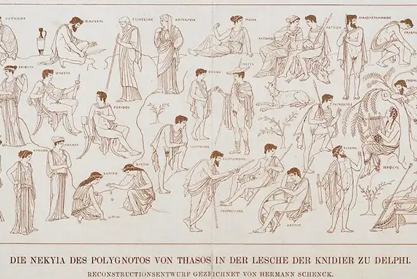
Hermann Schenck (March 16, 1829 - October 9, 1912) was a German lithographic printer, draughtsman, and painter based in Halle and Berlin. He was an employee of the Lithographische Anstalt Albert Meyer, founded by Albert Meyer (1817 - 1880) and Wilhelm Engel as the first lithographic printshop in Halle in 1843. After Engels left the business in 1855, Schenck took over management of it until 1862, when he left Halle established his own printing house in Berlin. The Lithographische Anstalt Albert Meyer was eventually taken over by Albert Meyer's son, Eugen Meyer (1855 - 1935) and upon his death by Albert Keil (as Lithographische Anstalt Albert Keil, vormals Albert Meyer) until 1939. As for Schenck, in 1870 he returned to Halle from Berlin to join the faculty of the Universität Halle (now part of Martin-Luther-Universität Halle-Wittenberg) as a drawing instructor and later as a professor. Over his career, Schenck worked in a wide range of media and methods, including engraving, lithography, sketches, watercolors, and oil paintings. Among his printed works were several dealing with archeology and Biblical themes, while his paintings included landscapes and portraits.
First specific map of the Atacama Desert.
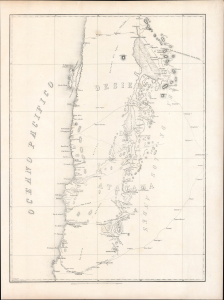
[Desierto De Atacama].
$1,500.00
Acquire
- Digital Map Information
- Suitable for large format printing
- Full resolution TIFF file
- ICC color profile embedded
- Delivered instantly via download link
Likely the first specific map of Chile's Atacama Desert, this is Wilhelm Döll's 1854 survey of Atacama, prepared during Rodolfo Amando Philippi's government-sponsored expedition into the largely uncharted interior. Extending from Cobija to Copiapó and eastward across salt flats, volcanic ranges, mining districts, and high Andean routes, it captures the Atacama at a pivotal moment—when scientific exploration, indigenous geography, silver discoveries, and competing Chilean and Bolivian territorial ambitions were beginning to transform the desert. Both a record of extraordinary fieldwork under conditions of extreme aridity and a harbinger of the mineral development and international conflict that followed, the map helped establish the geographical foundations for Chile's expanding interest in its northern frontier. (more details)