
Service géographique du Maroc

The Service géographique du Maroc (1920 - c. 1961) was a government office created as part of the colonial French protectorate. The Service géographique du Maroc was based in Casablanca and was the successor to the Bureau topographique du Maroc (founded in 1907). It was organized much in the same way was the Service géographique de l'Armée in Paris. The Bureau topographique du Maroc received its first lithographic presses (4 of them to be specific) in 1914. Before then, all materials created by the Bureau were printed and published in Paris. It is unclear exactly when the Service géographique du Maroc ceased to exist. Morocco gained its independence from France in 1955, but it appears the Service géographique du Maroc continued under the aegis of a Moroccan government agency until 1961 when it was taken over by the Moroccan government.
Published only a few years before the beginning of World War II.
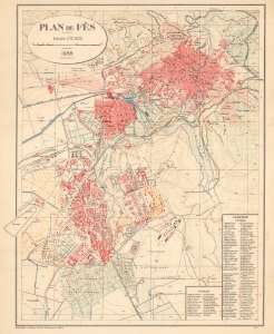
Plan de Fès.
$950.00
Acquire
- Digital Map Information
- Suitable for large format printing
- File Size: 31.33 MB
- File Type: ZIP / TIFF
- ICC color profile embedded
- Delivered instantly via download link
This is a rare 1938 Service géographique du Maroc city plan or map of Fes, Morocco. Published just prior to World War II, the map underscores the transformative impact of 25 years of French colonial influence on the Moroccoan urbanscape. It dramatically illustrates the contrast between the planned French ville nouvelle and the millenia-old ville indigene. (more details)