
Sidney, James Charles

James Charles Sidney (1819 – April 27, 1881) was an English-American architect, civil engineer, surveyor, and landscape architect based in Philadelphia. Sidney was born in England and emigrated to the United States, settling in Philadelphia, around 1840. His first cartographic works appear in the late 1840s when he partnered with Robert Pearsall Smith to survey several new large format maps of the Philadelphia region. In the 1849 Philadelphia Directory, he appears as a civil engineer and by c. 1850, he had established a partnership with the architect James P. W. Neff, Sidney and Neff, located at 80 Walnut Street. Around this time, he also published his most important work on architecture, American Cottage and Villa Architecture . The partnership with Neff dissolved c. 1854. It may have been because he was neglecting the architecture business to procures more maps for Smith, including the 1852 Map of the City and Vicinity of Boston. After 1854 he briefly relocated to New York to participate in Smith's mapping of that state. He returned to Philadelphia in 1857 forming a partnership with Andrew Adams, an architect and surveyor. During this time he completed a masterplan for Philadelphia's Fairmont Park, which was adopted and approved by the city council in 1859. The partnership with Adams dissolved one year later in 1860. In 1864 he took a new partner, Frederick C. Merry, founding Sidney and Merry, which continued the work on Fairmont Park and later Chestnut Hill. From 1865, Sidney worked independently and spent the rest of his careers designing schools for the Controllers of the Public Schools of Philadelphia. He became a member of the American Institute of Architects in 1870. Sidney's initials are often misrepresented on maps as J. G. and/or F. C.
On the cover of Ristow's 'Maps and Mapmakers.'
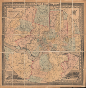
Map of the Circuit of Ten Miles Around the City of Philadelphia With the names of Villages, Roads, Milles, Property Owner, Taverns, etc. / Sidney's Map of Ten Miles round.
$3,800.00
Acquire
- Digital Map Information
- Suitable for large format printing
- File Size: 35.64 MB
- File Type: ZIP / TIFF
- ICC color profile embedded
- Delivered instantly via download link
This is an attractive example of J. C. Sidney's 1847 map of Philadelphia, covering the city and its vicinity 'Ten Miles round'. Smith, the publisher, considered this one of the 'most successful of his maps'. Water Ristow, in American Maps and Mapmakers, placed this map on the cover, devoted a full-page illustration to it, and included several pages of text, underscoring its significance as an example of mid-19th-century American map publishing. Indeed, its producers were a who's who of Philadelphia map publishing: Robert Persall Smith, Norman Friend, Augustus Köllner, Peter Steven Duval, and James Charles Sidney. (more details)
Poughkeepsie and Hyde Park.
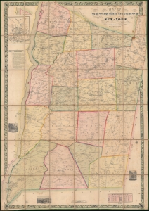
Map of Dutchess County New-York From Original Surveys.
$2,200.00
Acquire
- Digital Map Information
- Suitable for large format printing
- DPI: 600
- File Size: 242.51 MB
- File Type: ZIP / TIFF
- ICC color profile embedded
- Delivered instantly via download link
This is an 1850 James C. Sidney wall map of Dutchess County, New York, published a year after the Hudson River Railroad reached Poughkeepsie and a year before it reached Albany. The map marks a definitive moment in Dutchess County history, when the railroad opened the region - for the first time, to large-scale commerce and industry. This is, consequently, the largest and best early map of Dutchess County to appear before the American Civil War (1861 - 1865). This is moreover, an exceptional example of an early-American county map, the precursor of later town and county maps by Beers, Walling, and others. (more details)