1850 Sidney Map of Duchess County, New York
DuchessCountyNY-sidney-1850$2,200.00

Title
Map of Dutchess County New-York From Original Surveys.
1850 (dated) 57.5 x 41 in (146.05 x 104.14 cm) 1 : 42240
1850 (dated) 57.5 x 41 in (146.05 x 104.14 cm) 1 : 42240
Description
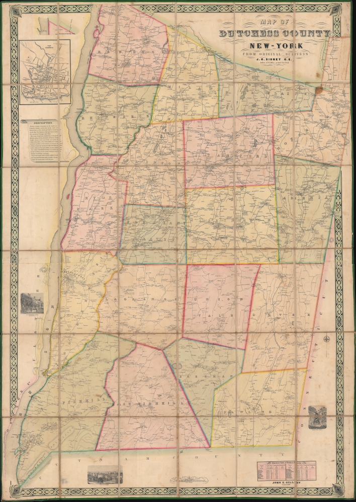
This is an 1850 James C. Sidney wall map of Dutchess County, New York, published a year after the Hudson River Railroad reached Poughkeepsie and a year before it reached Albany. The map marks a definitive moment in Dutchess County history, when the railroad opened the region - for the first time, to large-scale commerce and industry. This is, consequently, the largest and best early map of Dutchess County to appear before the American Civil War (1861 - 1865). This is moreover, an exceptional example of an early-American county map, the precursor of later town and county maps by Beers, Walling, and others.
A Closer Look
The map's impressive size allows for significant detail, with cities, towns, and villages meticulously identified. Individual residences are also labeled throughout, along with schools, churches, hotels, shops, and other businesses. The Hudson Railroad is striking as it hugs the river's east bank. An inset of Poughkeepsie occupies the upper left corner just above a short description of Dutchess County. The northernmost part of Dutchess County appears in the extreme upper right, slightly removed from where it ought to be since the map already extends past the top border along the Hudson. Sidney employs this tactic a second time, displacing the northern extension of North East to the left since it would otherwise extend well off the right side of the map. Three vignettes depict the Dover Stone Church, Matteawan, and the Poughkeepsie Hotel. A statistical table of Dutchess County appears in the bottom right.Historical Context
In 1850, Dutchess County was a thriving agricultural region known for its beautiful farmland, particularly for the production of wheat, corn, and oats. The county seat of Poughkeepsie was a hub of trade and commerce, with a bustling waterfront. The Hudson Railroad reached Poughkeepsie in 1849, providing improved transportation and commercial opportunities. A year later, it extended to Albany, transforming Poughkeepsie from a river town into a railroad hub, the heart of a network that expanded in subsequent decades.Publication History and Census
This map was created by James Charles Sidney and published by Robert Pearsall Smith and John E. Gillette. We note four examples cataloged in OCLC: New York Public Library, State University of New York Binghamton, Cornell University, the University of California Berkeley, and the Library of Congress.CartographerS
James Charles Sidney (1819 – April 27, 1881) was an English-American architect, civil engineer, surveyor, and landscape architect based in Philadelphia. Sidney was born in England and emigrated to the United States, settling in Philadelphia, around 1840. His first cartographic works appear in the late 1840s when he partnered with Robert Pearsall Smith to survey several new large format maps of the Philadelphia region. In the 1849 Philadelphia Directory, he appears as a civil engineer and by c. 1850, he had established a partnership with the architect James P. W. Neff, Sidney and Neff, located at 80 Walnut Street. Around this time, he also published his most important work on architecture, American Cottage and Villa Architecture . The partnership with Neff dissolved c. 1854. It may have been because he was neglecting the architecture business to procures more maps for Smith, including the 1852 Map of the City and Vicinity of Boston. After 1854 he briefly relocated to New York to participate in Smith's mapping of that state. He returned to Philadelphia in 1857 forming a partnership with Andrew Adams, an architect and surveyor. During this time he completed a masterplan for Philadelphia's Fairmont Park, which was adopted and approved by the city council in 1859. The partnership with Adams dissolved one year later in 1860. In 1864 he took a new partner, Frederick C. Merry, founding Sidney and Merry, which continued the work on Fairmont Park and later Chestnut Hill. From 1865, Sidney worked independently and spent the rest of his careers designing schools for the Controllers of the Public Schools of Philadelphia. He became a member of the American Institute of Architects in 1870. Sidney's initials are often misrepresented on maps as J. G. and/or F. C. More by this mapmaker...
Robert Pearsall Smith (February 1, 1827 - April 17, 1898) was an American map maker active in Philadelphia from the middle to late 19th century. Smith was born to a Quaker family in Philadelphia, all librarians and publishers. Robert Pearsall originally ran a law bookstore at 19 James Street, Philadelphia. It was not until 1846 that Smith began producing maps in collaboration with this father, John Jay Smith, and brother, Lloyd P. Smith. One year earlier, in 1845, John Jay, then librarian at the Library Company of Philadelphia and Loganian Library, acquired the American rights to the anastatic process of transfer lithography. In February of 1846 he and his two sons founded the Anastatic Office, a printing concern based on the anastatic process located at 317 Market Street, Philadelphia. The Anastatic Office produced numerous copies and reissues of historic documents and maps from the Library Company's collection before being dissolved in 1847. In the same year Robert Pearsall opened a printing establishment under his own name at 144 Chestnut Street. In 1858, he joined forced with the Swiss-American engraver Frederick Bourquin (1808 - 1897) under the imprint 'F. Bourquin and Company' (602 Chestnut Street). Smith retired suddenly and inexplicably from the printing business around 1865. Smith was also deeply religious, a lay leader in the Holiness Movement in the United States and the Higher Life Movement in Great Britain. Smith and his wife, Hannah Tatum Whitall, first crossed the Atlantic to preach in England, Germany and Switzerland in 1873. They returned in 1875, preaching in Brighton, where Smith supposedly had an affair with an American writer. In, 1888, his entire family moved to England. Learn More...
John Edward Gillette (1828 - March 10, 1911) was an American map publisher. Gillette published several county maps of New York as well as a map of the vicinity of Philadelphia. Gillette died in Hudson, New York. Per his obituary, Gillette 'is best remembered as the organizer of the American Paper Car Wheel Company, whose process of making wheels of pressed paper was successful from the start'. Learn More...
Condition
Good. Dissected and mounted on linen in 36 panels. Dampstaining visible on verso.
References
Library of Congress G3803.D8 1850 .S4. OCLC 46797238.